Konia geodata
Konia (Pafos) is a populated place; located in Cyprus in Asia/Nicosia (GMT+2) time zone. With population of 2,209 people, there are 45 cities with bigger population in this country. Compared to other cities in Cyprus, 78.6% of cities are located further ↑North; 89.7% of cities are located further →East and 70.1% of cities have lower elevation than Konia. Note1


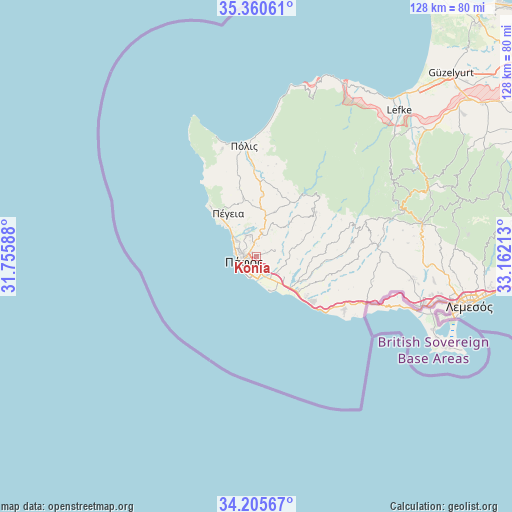
Konia GPS coordinates[2]
34° 47' 6.576" North, 32° 27' 32.4" East
| Map corner | latitude | longitude |
|---|---|---|
| Upper-left | 35.36061°, | 31.75588° |
| Center: | 34.78516°, | 32.459° |
| Lower-right: | 34.20567°, | 33.16213° |
| Map W x H: | 128.4×128.4 km | = 79.8×79.8mi |
| max Lat: | 35.59719° ⇑78.6% North |
| Konia: | 34.78516° |
| min Lat: | ⇓21.4% South 34.66865° |
| min Long | Konia | max Long |
| 32.38166° | 32.459° | 34.37916° |
| W 10.3%⇐ | ⇒89.7% E |
Elevation
Elevation of Konia is 252 m = 827 ft, and this is 44 m = 144 ft above average elevation for this country.
| Max E: |
1134 m = 3720 ft | 29.9% |
| Konia | 252 m 827 ft | |
| Avg. | 208 m = 682 ft | |
Min E: |
4 m = 13 ft | 70.1% |
See also: Cyprus elevation on elevation.city.
Geographical zone
Konia is located in North temperate zone (between Tropic of Cancer and the Arctic Circle). Distance of this Northern Tropic circle is 1261.8 km =784 mi to South.| Distance of | km | miles | from Konia |
|---|---|---|---|
| North Pole | 6139.3 | 3814.8 | to North |
| Arctic Circle | 3533.4 | 2195.6 | to North |
| Tropic Cancer | 1261.8 | 784 | to South |
| Equator | 3867.7 | 2403.3 | to South |


Nearby cities:
15 places around Konia: (largest is in red/bold)
• Anaríta
8.4 km =5.2 mi,  125°
125°
• Chlórakas
4.5 km =2.8 mi,  287°
287°
• Emba
4 km =2.5 mi,  307°
307°
• Geroskipou
3.4 km =2.1 mi,  191°
191°
• Geroskípou (quarter)
2.7 km =1.7 mi,  195°
195°
• Kissonerga
6.7 km =4.2 mi, 308°
• Koloni
3.7 km =2.3 mi,  171°
171°
• Lempa
5.3 km =3.3 mi,  299°
299°
• Mesógi
3.4 km =2.1 mi,  354°
354°
• Paphos
3.3 km =2.1 mi,  253°
253°
• Stroumpí
11.1 km =6.9 mi,  10°
10°
• Tsada - Tremithousa - Tala (Borders)
5.5 km =3.4 mi, 354°
• Tsáda
6.1 km =3.8 mi, 14°
• Tála
6.3 km =3.9 mi,  337°
337°
• Tími
7.8 km =4.8 mi,  138°
138°
Sources, notices
• [Note1] Compared only with cities in Cyprus existing in our database
• [Src1] Map data: © OpenStreetMap contributors (CC-BY-SA)
• [Src2] Other city data from geonames.org with taken over terms of usage.
• [Src3] Geographical zone / Annual Mean Temperature by Robert A. Rohde @ Wikipedia
