Kissonerga geodata
Kissonerga (Pafos) is a populated place; located in Cyprus in Asia/Nicosia (GMT+2) time zone. With population of 2,004 people, there are 49 cities with bigger population in this country. Compared to other cities in Cyprus, 72.6% of cities are located further ↑North; 99.1% of cities are located further →East and 52.1% of cities have higher elevation than Kissonerga. Note1


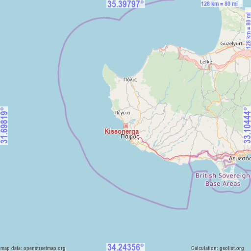
Kissonerga GPS coordinates[2]
34° 49' 22.044" North, 32° 24' 4.716" East
| Map corner | latitude | longitude |
|---|---|---|
| Upper-left | 35.39797°, | 31.69819° |
| Center: | 34.82279°, | 32.40131° |
| Lower-right: | 34.24356°, | 33.10444° |
| Map W x H: | 128.4×128.4 km | = 79.8×79.8mi |
| max Lat: | 35.59719° ⇑72.6% North |
| Kissonerga: | 34.82279° |
| min Lat: | ⇓27.4% South 34.66865° |
| min Long | Kissonerga | max Long |
| 32.38166° | 32.40131° | 34.37916° |
| W 0.9%⇐ | ⇒99.1% E |
Elevation
Elevation of Kissonerga is 112 m = 367 ft, and this is 96 m = 315 ft below average elevation for this country.
| Max E: |
1134 m = 3720 ft | 52.1% |
| Avg. | 208 m = 682 ft | |
| Kissonerga | 112 m = 367 ft | |
Min E: |
4 m = 13 ft | 47.9% |
See also: Cyprus elevation on elevation.city.
Geographical zone
Kissonerga is located in North temperate zone (between Tropic of Cancer and the Arctic Circle). Distance of this Northern Tropic circle is 1266 km =786.7 mi to South.| Distance of | km | miles | from Kissonerga |
|---|---|---|---|
| North Pole | 6135.1 | 3812.2 | to North |
| Arctic Circle | 3529.2 | 2192.9 | to North |
| Tropic Cancer | 1266 | 786.7 | to South |
| Equator | 3871.9 | 2405.9 | to South |


Nearby cities:
15 places around Kissonerga: (largest is in red/bold)
• Chlórakas
3 km =1.9 mi,  160°
160°
• Emba
2.7 km =1.7 mi,  130°
130°
• Geroskipou
8.8 km =5.5 mi,  148°
148°
• Geroskípou (quarter)
8.2 km =5.1 mi, 145°
• Koloni
9.8 km =6.1 mi,  143°
143°
• Konia
6.7 km =4.2 mi, 128°
• Lempa
1.7 km =1.1 mi, 159°
• Mesógi
5 km =3.1 mi,  98°
98°
• Paphos
5.5 km =3.4 mi, 157°
• Polémi
12.1 km =7.5 mi,  54°
54°
• Pégeia
7 km =4.3 mi,  345°
345°
• Stroumpí
9.9 km =6.2 mi, 47°
• Tsada - Tremithousa - Tala (Borders)
4.9 km =3 mi,  74°
74°
• Tsáda
7 km =4.3 mi,  75°
75°
• Tála
3.3 km =2.1 mi,  60°
60°
Sources, notices
• [Note1] Compared only with cities in Cyprus existing in our database
• [Src1] Map data: © OpenStreetMap contributors (CC-BY-SA)
• [Src2] Other city data from geonames.org with taken over terms of usage.
• [Src3] Geographical zone / Annual Mean Temperature by Robert A. Rohde @ Wikipedia
