Bammental geodata
Bammental (Baden-Württemberg) is a seat of a fourth-order administrative division; located in Germany in Europe/Berlin (GMT+2) time zone. With population of 6,493 people, there are 2309 cities with bigger population in this country. Compared to other cities in Germany, 77.8% of cities are located further ↑North; 68.2% of cities are located further →East and 63.6% of cities have higher elevation than Bammental. Note1
Administrative division(s):
- Level 1: Baden-Württemberg
- Level 2: Karlsruhe Region
- Level 3: Rhein-Neckar-Kreis
- Level 4: Bammental


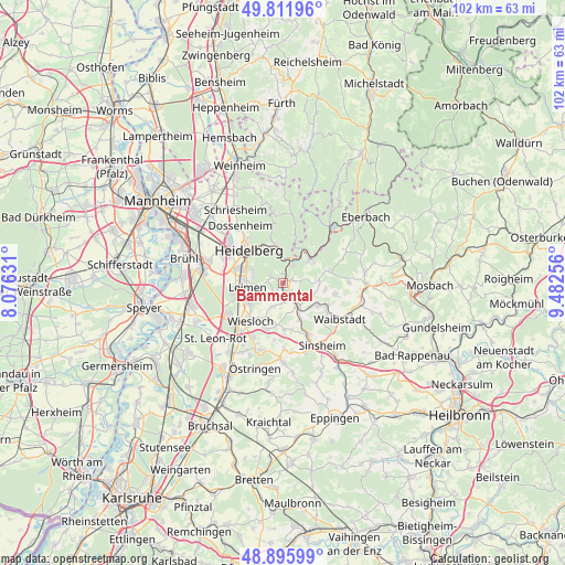
Bammental GPS coordinates[2]
49° 21' 21.996" North, 8° 46' 45.984" East
| Map corner | latitude | longitude |
|---|---|---|
| Upper-left | 49.81196°, | 8.07631° |
| Center: | 49.35611°, | 8.77944° |
| Lower-right: | 48.89599°, | 9.48256° |
| Map W x H: | 101.8×101.8 km | = 63.3×63.3mi |
| max Lat: | 55.01917° ⇑77.8% North |
| Bammental: | 49.35611° |
| min Lat: | ⇓22.2% South 47.40724° |
| min Long | Bammental | max Long |
| 5.92978° | 8.77944° | 14.98853° |
| W 31.8%⇐ | ⇒68.2% E |
Elevation
Elevation of Bammental is 128 m = 420 ft, and this is 121.1 m = 397 ft below average elevation for this country.
| Max E: |
1256 m = 4121 ft | 63.6% |
| Avg. | 249.1 m = 817 ft | |
| Bammental | 128 m = 420 ft | |
Min E: |
-5 m = -16 ft | 36.4% |
See also: Germany elevation on elevation.city.
Geographical zone
Bammental is located in North temperate zone (between Tropic of Cancer and the Arctic Circle). Distance of this North polar circle is 1913.3 km =1188.9 mi to North.| Distance of | km | miles | from Bammental |
|---|---|---|---|
| North Pole | 4519.2 | 2808.1 | to North |
| Arctic Circle | 1913.3 | 1188.9 | to North |
| Tropic Cancer | 2882 | 1790.8 | to South |
| Equator | 5487.9 | 3410 | to South |


Nearby cities:
15 places around Bammental: (largest is in red/bold)
• Dielheim
8.5 km =5.3 mi,  200°
200°
• Eschelbronn
7.4 km =4.6 mi,  123°
123°
• Gaiberg
2.4 km =1.5 mi,  297°
297°
• Heidelberg
8.6 km =5.3 mi,  311°
311°
• Horrenberg
8.4 km =5.2 mi,  179°
179°
• Leimen
6.7 km =4.2 mi,  261°
261°
• Lobbach
8.2 km =5.1 mi,  75°
75°
• Mauer
2.3 km =1.4 mi,  138°
138°
• Meckesheim
4.8 km =3 mi, 142°
• Neckargemünd
3.8 km =2.4 mi,  18°
18°
• Neckarsteinach
7.3 km =4.5 mi,  39°
39°
• Nußloch
7.1 km =4.4 mi,  239°
239°
• Spechbach
7.6 km =4.7 mi,  98°
98°
• Wiesenbach
1.8 km =1.1 mi,  71°
71°
• Zuzenhausen
7.3 km =4.5 mi,  154°
154°
Sources, notices
• [Note1] Compared only with cities in Germany existing in our database
• [Src1] Map data: © OpenStreetMap contributors (CC-BY-SA)
• [Src2] Other city data from geonames.org with taken over terms of usage.
• [Src3] Geographical zone / Annual Mean Temperature by Robert A. Rohde @ Wikipedia
