Mühlhausen geodata
Mühlhausen (Baden-Württemberg) is a seat of a fourth-order administrative division; located in Germany in Europe/Berlin (GMT+2) time zone. With population of 8,176 people, there are 1931 cities with bigger population in this country. Compared to other cities in Germany, 79.6% of cities are located further ↑North; 68.8% of cities are located further →East and 61.3% of cities have higher elevation than Mühlhausen. Note1
Administrative division(s):
- Level 1: Baden-Württemberg
- Level 2: Karlsruhe Region
- Level 3: Rhein-Neckar-Kreis
- Level 4: Mühlhausen


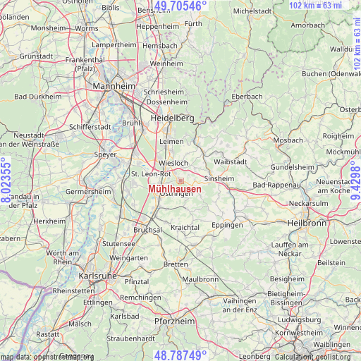
Mühlhausen GPS coordinates[2]
49° 14' 54.996" North, 8° 43' 36.012" East
| Map corner | latitude | longitude |
|---|---|---|
| Upper-left | 49.70546°, | 8.02355° |
| Center: | 49.24861°, | 8.72667° |
| Lower-right: | 48.78749°, | 9.4298° |
| Map W x H: | 102.1×102.1 km | = 63.4×63.4mi |
| max Lat: | 55.01917° ⇑79.6% North |
| Mühlhausen: | 49.24861° |
| min Lat: | ⇓20.4% South 47.40724° |
| min Long | Mühlhausen | max Long |
| 5.92978° | 8.72667° | 14.98853° |
| W 31.2%⇐ | ⇒68.8% E |
Elevation
Elevation of Mühlhausen is 143 m = 469 ft, and this is 106.1 m = 348 ft below average elevation for this country.
| Max E: |
1256 m = 4121 ft | 61.3% |
| Avg. | 249.1 m = 817 ft | |
| Mühlhausen | 143 m = 469 ft | |
Min E: |
-5 m = -16 ft | 38.7% |
See also: Germany elevation on elevation.city.
Geographical zone
Mühlhausen is located in North temperate zone (between Tropic of Cancer and the Arctic Circle). Distance of this North polar circle is 1925.2 km =1196.3 mi to North.| Distance of | km | miles | from Mühlhausen |
|---|---|---|---|
| North Pole | 4531.1 | 2815.5 | to North |
| Arctic Circle | 1925.2 | 1196.3 | to North |
| Tropic Cancer | 2870 | 1783.3 | to South |
| Equator | 5475.9 | 3402.6 | to South |


Nearby cities:
15 places around Mühlhausen: (largest is in red/bold)
• Balzfeld
5.1 km =3.2 mi,  63°
63°
• Dielheim
4 km =2.5 mi,  11°
11°
• Horrenberg
5.3 km =3.3 mi,  48°
48°
• Kronau
7.5 km =4.7 mi,  247°
247°
• Leimen
11.3 km =7 mi,  345°
345°
• Malsch
3.2 km =2 mi,  267°
267°
• Meckesheim
10.5 km =6.5 mi,  39°
39°
• Nußloch
8.7 km =5.4 mi,  344°
344°
• Rauenberg
2.9 km =1.8 mi,  323°
323°
• Sankt Leon-Rot
8.1 km =5 mi,  283°
283°
• Sinsheim
11 km =6.8 mi,  87°
87°
• Walldorf
8.9 km =5.5 mi, 316°
• Wiesloch
5.6 km =3.5 mi, 338°
• Zuzenhausen
8.7 km =5.4 mi, 52°
• Östringen
3.5 km =2.2 mi,  198°
198°
Sources, notices
• [Note1] Compared only with cities in Germany existing in our database
• [Src1] Map data: © OpenStreetMap contributors (CC-BY-SA)
• [Src2] Other city data from geonames.org with taken over terms of usage.
• [Src3] Geographical zone / Annual Mean Temperature by Robert A. Rohde @ Wikipedia
