Zörnigall geodata
Zörnigall (Saxony-Anhalt) is a populated place; located in Germany in Europe/Berlin (GMT+2) time zone. With population of 991 people, there are 7219 cities with bigger population in this country. Compared to other cities in Germany, 70.7% of cities are located further ↓South; 90.4% of cities are located further ←West and 72.3% of cities have higher elevation than Zörnigall. Note1
Administrative division(s):
- Level 1: Saxony-Anhalt
- Level 3: Landkreis Wittenberg
- Level 4: Zahna-Elster


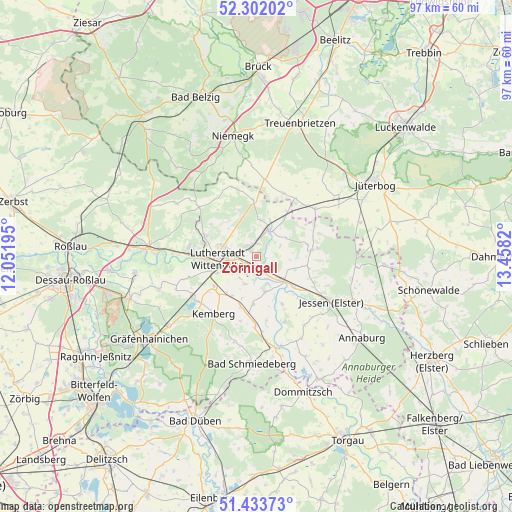
Zörnigall GPS coordinates[2]
51° 52' 11.892" North, 12° 45' 18.252" East
| Map corner | latitude | longitude |
|---|---|---|
| Upper-left | 52.30202°, | 12.05195° |
| Center: | 51.86997°, | 12.75507° |
| Lower-right: | 51.43373°, | 13.4582° |
| Map W x H: | 96.5×96.5 km | = 60×60mi |
| max Lat: | 55.01917° ⇑29.3% North |
| Zörnigall: | 51.86997° |
| min Lat: | ⇓70.7% South 47.40724° |
| min Long | Zörnigall | max Long |
| 5.92978° | 12.75507° | 14.98853° |
| W 90.4%⇐ | ⇒9.6% E |
Elevation
Elevation of Zörnigall is 76 m = 249 ft, and this is 173.1 m = 568 ft below average elevation for this country.
| Max E: |
1256 m = 4121 ft | 72.3% |
| Avg. | 249.1 m = 817 ft | |
| Zörnigall | 76 m = 249 ft | |
Min E: |
-5 m = -16 ft | 27.7% |
See also: Germany elevation on elevation.city.
Geographical zone
Zörnigall is located in North temperate zone (between Tropic of Cancer and the Arctic Circle). Distance of this North polar circle is 1633.8 km =1015.2 mi to North.| Distance of | km | miles | from Zörnigall |
|---|---|---|---|
| North Pole | 4239.7 | 2634.4 | to North |
| Arctic Circle | 1633.8 | 1015.2 | to North |
| Tropic Cancer | 3161.5 | 1964.5 | to South |
| Equator | 5767.4 | 3583.7 | to South |


Nearby cities:
15 places around Zörnigall: (largest is in red/bold)
• Abtsdorf
3 km =1.9 mi,  317°
317°
• Bülzig
2.7 km =1.7 mi,  0°
0°
• Dabrun
5.2 km =3.2 mi,  217°
217°
• Elster
6.5 km =4 mi,  133°
133°
• Elstervorstadt
4.5 km =2.8 mi,  262°
262°
• Friedrichstadt
6.2 km =3.9 mi,  288°
288°
• Mochau
8.5 km =5.3 mi, 322°
• Mühlanger
2.2 km =1.4 mi,  188°
188°
• Pratau
8.2 km =5.1 mi,  248°
248°
• Rackith
8.8 km =5.5 mi,  212°
212°
• Rothemark
9.5 km =5.9 mi,  277°
277°
• Teuchel
7.8 km =4.8 mi, 285°
• Wartenburg
6.9 km =4.3 mi,  166°
166°
• Wittenberg
7.2 km =4.5 mi,  266°
266°
• Zahna
5.3 km =3.3 mi,  23°
23°
Sources, notices
• [Note1] Compared only with cities in Germany existing in our database
• [Src1] Map data: © OpenStreetMap contributors (CC-BY-SA)
• [Src2] Other city data from geonames.org with taken over terms of usage.
• [Src3] Geographical zone / Annual Mean Temperature by Robert A. Rohde @ Wikipedia
