Bülzig geodata
Bülzig (Saxony-Anhalt) is a populated place; located in Germany in Europe/Berlin (GMT+2) time zone. With population of 815 people, there are 7840 cities with bigger population in this country. Compared to other cities in Germany, 71% of cities are located further ↓South; 90.4% of cities are located further ←West and 69.4% of cities have higher elevation than Bülzig. Note1
Administrative division(s):
- Level 1: Saxony-Anhalt
- Level 3: Landkreis Wittenberg
- Level 4: Zahna-Elster


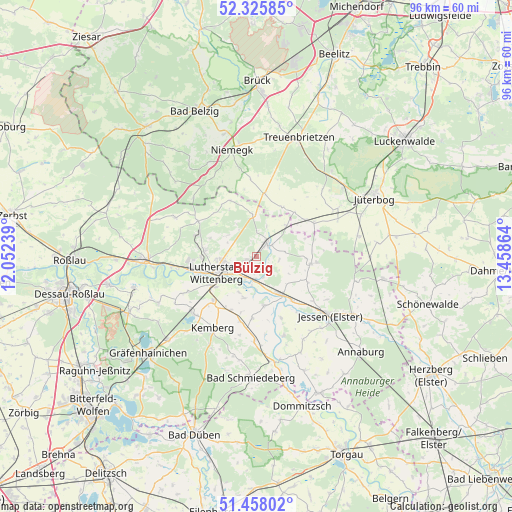
Bülzig GPS coordinates[2]
51° 53' 38.508" North, 12° 45' 19.836" East
| Map corner | latitude | longitude |
|---|---|---|
| Upper-left | 52.32585°, | 12.05239° |
| Center: | 51.89403°, | 12.75551° |
| Lower-right: | 51.45802°, | 13.45864° |
| Map W x H: | 96.5×96.5 km | = 60×60mi |
| max Lat: | 55.01917° ⇑29% North |
| Bülzig: | 51.89403° |
| min Lat: | ⇓71% South 47.40724° |
| min Long | Bülzig | max Long |
| 5.92978° | 12.75551° | 14.98853° |
| W 90.4%⇐ | ⇒9.6% E |
Elevation
Elevation of Bülzig is 95 m = 312 ft, and this is 154.1 m = 506 ft below average elevation for this country.
| Max E: |
1256 m = 4121 ft | 69.4% |
| Avg. | 249.1 m = 817 ft | |
| Bülzig | 95 m = 312 ft | |
Min E: |
-5 m = -16 ft | 30.6% |
See also: Germany elevation on elevation.city.
Geographical zone
Bülzig is located in North temperate zone (between Tropic of Cancer and the Arctic Circle). Distance of this North polar circle is 1631.1 km =1013.5 mi to North.| Distance of | km | miles | from Bülzig |
|---|---|---|---|
| North Pole | 4237 | 2632.7 | to North |
| Arctic Circle | 1631.1 | 1013.5 | to North |
| Tropic Cancer | 3164.2 | 1966.1 | to South |
| Equator | 5770.1 | 3585.4 | to South |


Nearby cities:
15 places around Bülzig: (largest is in red/bold)
• Abtsdorf
2.1 km =1.3 mi,  257°
257°
• Dabrun
7.5 km =4.7 mi,  205°
205°
• Elster
8.5 km =5.3 mi,  146°
146°
• Elstervorstadt
5.5 km =3.4 mi,  233°
233°
• Friedrichstadt
5.9 km =3.7 mi, 262°
• Kropstädt
7.7 km =4.8 mi,  354°
354°
• Mochau
6.6 km =4.1 mi,  308°
308°
• Mühlanger
4.9 km =3 mi,  184°
184°
• Pratau
9.6 km =6 mi, 233°
• Rothemark
9.6 km =6 mi, 261°
• Teuchel
7.5 km =4.7 mi,  265°
265°
• Wartenburg
9.5 km =5.9 mi,  170°
170°
• Wittenberg
7.9 km =4.9 mi,  246°
246°
• Zahna
3 km =1.9 mi,  42°
42°
• Zörnigall
2.7 km =1.7 mi, 180°
Sources, notices
• [Note1] Compared only with cities in Germany existing in our database
• [Src1] Map data: © OpenStreetMap contributors (CC-BY-SA)
• [Src2] Other city data from geonames.org with taken over terms of usage.
• [Src3] Geographical zone / Annual Mean Temperature by Robert A. Rohde @ Wikipedia
