Mühlanger geodata
Mühlanger (Saxony-Anhalt) is a seat of a fourth-order administrative division; located in Germany in Europe/Berlin (GMT+2) time zone. With population of 1,467 people, there are 5944 cities with bigger population in this country. Compared to other cities in Germany, 70.5% of cities are located further ↓South; 90.3% of cities are located further ←West and 73.4% of cities have higher elevation than Mühlanger. Note1
Administrative division(s):
- Level 1: Saxony-Anhalt
- Level 3: Landkreis Wittenberg
- Level 4: Zahna-Elster


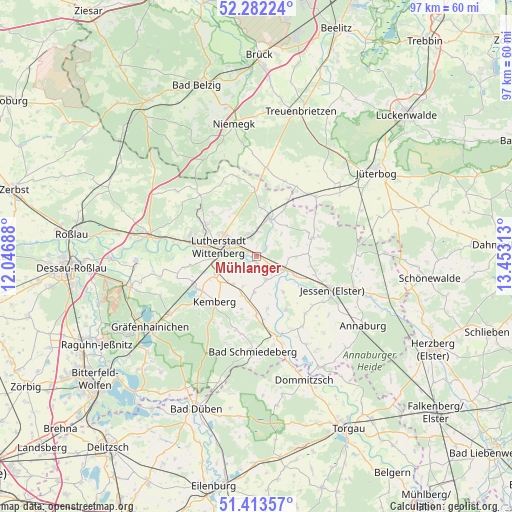
Mühlanger GPS coordinates[2]
51° 51' 0" North, 12° 45' 0" East
| Map corner | latitude | longitude |
|---|---|---|
| Upper-left | 52.28224°, | 12.04688° |
| Center: | 51.85°, | 12.75° |
| Lower-right: | 51.41357°, | 13.45313° |
| Map W x H: | 96.6×96.6 km | = 60×60mi |
| max Lat: | 55.01917° ⇑29.5% North |
| Mühlanger: | 51.85° |
| min Lat: | ⇓70.5% South 47.40724° |
| min Long | Mühlanger | max Long |
| 5.92978° | 12.75° | 14.98853° |
| W 90.3%⇐ | ⇒9.7% E |
Elevation
Elevation of Mühlanger is 70 m = 230 ft, and this is 179.1 m = 588 ft below average elevation for this country.
| Max E: |
1256 m = 4121 ft | 73.4% |
| Avg. | 249.1 m = 817 ft | |
| Mühlanger | 70 m = 230 ft | |
Min E: |
-5 m = -16 ft | 26.6% |
See also: Germany elevation on elevation.city.
Geographical zone
Mühlanger is located in North temperate zone (between Tropic of Cancer and the Arctic Circle). Distance of this North polar circle is 1636 km =1016.6 mi to North.| Distance of | km | miles | from Mühlanger |
|---|---|---|---|
| North Pole | 4241.9 | 2635.8 | to North |
| Arctic Circle | 1636 | 1016.6 | to North |
| Tropic Cancer | 3159.3 | 1963.1 | to South |
| Equator | 5765.2 | 3582.3 | to South |


Nearby cities:
15 places around Mühlanger: (largest is in red/bold)
• Abtsdorf
4.7 km =2.9 mi,  339°
339°
• Bülzig
4.9 km =3 mi,  4°
4°
• Dabrun
3.4 km =2.1 mi,  235°
235°
• Elster
5.6 km =3.5 mi,  113°
113°
• Elstervorstadt
4.4 km =2.7 mi,  291°
291°
• Eutzsch
8.4 km =5.2 mi,  246°
246°
• Friedrichstadt
6.9 km =4.3 mi,  307°
307°
• Kleinwittenberg
9.4 km =5.8 mi,  281°
281°
• Pratau
7.4 km =4.6 mi,  263°
263°
• Rackith
6.8 km =4.2 mi,  220°
220°
• Teuchel
8.3 km =5.2 mi,  300°
300°
• Wartenburg
4.9 km =3 mi,  155°
155°
• Wittenberg
7.1 km =4.4 mi, 284°
• Zahna
7.5 km =4.7 mi,  18°
18°
• Zörnigall
2.2 km =1.4 mi,  8°
8°
Sources, notices
• [Note1] Compared only with cities in Germany existing in our database
• [Src1] Map data: © OpenStreetMap contributors (CC-BY-SA)
• [Src2] Other city data from geonames.org with taken over terms of usage.
• [Src3] Geographical zone / Annual Mean Temperature by Robert A. Rohde @ Wikipedia
