Zirndorf geodata
Zirndorf (Bavaria) is a seat of a third-order administrative division; located in Germany in Europe/Berlin (GMT+2) time zone. With population of 25,734 people, there are 563 cities with bigger population in this country. Compared to other cities in Germany, 76.6% of cities are located further ↑North; 66.3% of cities are located further ←West and 63.1% of cities have lower elevation than Zirndorf. Note1
Administrative division(s):
- Level 1: Bavaria
- Level 2: Regierungsbezirk Mittelfranken
- Level 3: Landkreis Fürth
- Level 4: Zirndorf


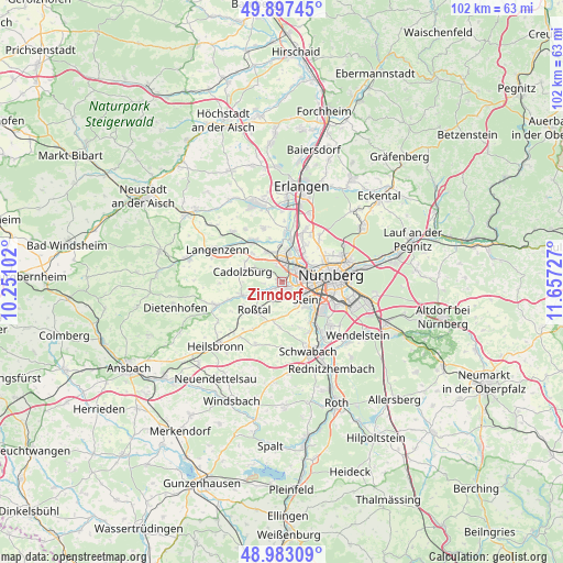
Zirndorf GPS coordinates[2]
49° 26' 32.64" North, 10° 57' 14.904" East
| Map corner | latitude | longitude |
|---|---|---|
| Upper-left | 49.89745°, | 10.25102° |
| Center: | 49.4424°, | 10.95414° |
| Lower-right: | 48.98309°, | 11.65727° |
| Map W x H: | 101.7×101.7 km | = 63.2×63.2mi |
| max Lat: | 55.01917° ⇑76.6% North |
| Zirndorf: | 49.4424° |
| min Lat: | ⇓23.4% South 47.40724° |
| min Long | Zirndorf | max Long |
| 5.92978° | 10.95414° | 14.98853° |
| W 66.3%⇐ | ⇒33.7% E |
Elevation
Elevation of Zirndorf is 309 m = 1014 ft, and this is 59.9 m = 197 ft above average elevation for this country.
| Max E: |
1256 m = 4121 ft | 36.9% |
| Zirndorf | 309 m 1014 ft | |
| Avg. | 249.1 m = 817 ft | |
Min E: |
-5 m = -16 ft | 63.1% |
See also: Germany elevation on elevation.city.
Geographical zone
Zirndorf is located in North temperate zone (between Tropic of Cancer and the Arctic Circle). Distance of this North polar circle is 1903.7 km =1182.9 mi to North.| Distance of | km | miles | from Zirndorf |
|---|---|---|---|
| North Pole | 4509.6 | 2802.1 | to North |
| Arctic Circle | 1903.7 | 1182.9 | to North |
| Tropic Cancer | 2891.6 | 1796.8 | to South |
| Equator | 5497.5 | 3416 | to South |


Nearby cities:
15 places around Zirndorf: (largest is in red/bold)
• Ammerndorf
7.8 km =4.8 mi,  254°
254°
• Cadolzburg
7.5 km =4.7 mi,  282°
282°
• Fürth
4.5 km =2.8 mi,  33°
33°
• Großreuth bei Schweinau
5 km =3.1 mi,  100°
100°
• Nürnberg
9 km =5.6 mi,  81°
81°
• Oberasbach
2.2 km =1.4 mi,  173°
173°
• Obermichelbach
10.4 km =6.5 mi,  341°
341°
• Puschendorf
12.7 km =7.9 mi,  315°
315°
• Rohr
12.2 km =7.6 mi,  202°
202°
• Roßtal
7 km =4.3 mi,  222°
222°
• Seukendorf
7.4 km =4.6 mi,  313°
313°
• Stein
5.4 km =3.4 mi,  123°
123°
• Tuchenbach
11.7 km =7.3 mi, 324°
• Veitsbronn
9.1 km =5.7 mi,  328°
328°
• Wetzendorf
7 km =4.3 mi,  63°
63°
Sources, notices
• [Note1] Compared only with cities in Germany existing in our database
• [Src1] Map data: © OpenStreetMap contributors (CC-BY-SA)
• [Src2] Other city data from geonames.org with taken over terms of usage.
• [Src3] Geographical zone / Annual Mean Temperature by Robert A. Rohde @ Wikipedia
