Seukendorf geodata
Seukendorf (Bavaria) is a seat of a fourth-order administrative division; located in Germany in Europe/Berlin (GMT+2) time zone. With population of 3,287 people, there are 3760 cities with bigger population in this country. Compared to other cities in Germany, 75.9% of cities are located further ↑North; 65.2% of cities are located further ←West and 65.8% of cities have lower elevation than Seukendorf. Note1
Administrative division(s):
- Level 1: Bavaria
- Level 2: Regierungsbezirk Mittelfranken
- Level 3: Landkreis Fürth
- Level 4: Seukendorf


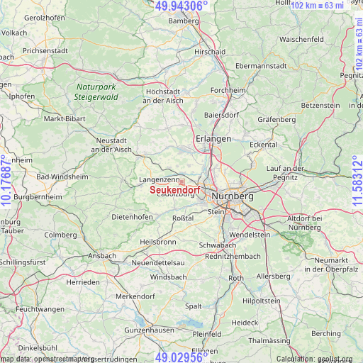
Seukendorf GPS coordinates[2]
49° 29' 18.384" North, 10° 52' 47.964" East
| Map corner | latitude | longitude |
|---|---|---|
| Upper-left | 49.94306°, | 10.17687° |
| Center: | 49.48844°, | 10.87999° |
| Lower-right: | 49.02956°, | 11.58312° |
| Map W x H: | 101.6×101.6 km | = 63.1×63.1mi |
| max Lat: | 55.01917° ⇑75.9% North |
| Seukendorf: | 49.48844° |
| min Lat: | ⇓24.1% South 47.40724° |
| min Long | Seukendorf | max Long |
| 5.92978° | 10.87999° | 14.98853° |
| W 65.2%⇐ | ⇒34.8% E |
Elevation
Elevation of Seukendorf is 327 m = 1073 ft, and this is 77.9 m = 256 ft above average elevation for this country.
| Max E: |
1256 m = 4121 ft | 34.2% |
| Seukendorf | 327 m 1073 ft | |
| Avg. | 249.1 m = 817 ft | |
Min E: |
-5 m = -16 ft | 65.8% |
See also: Germany elevation on elevation.city.
Geographical zone
Seukendorf is located in North temperate zone (between Tropic of Cancer and the Arctic Circle). Distance of this North polar circle is 1898.6 km =1179.7 mi to North.| Distance of | km | miles | from Seukendorf |
|---|---|---|---|
| North Pole | 4504.5 | 2799 | to North |
| Arctic Circle | 1898.6 | 1179.7 | to North |
| Tropic Cancer | 2896.7 | 1799.9 | to South |
| Equator | 5502.6 | 3419.2 | to South |


Nearby cities:
15 places around Seukendorf: (largest is in red/bold)
• Ammerndorf
7.6 km =4.7 mi,  196°
196°
• Cadolzburg
4 km =2.5 mi,  209°
209°
• Fürth
8 km =5 mi,  100°
100°
• Großreuth bei Schweinau
11.9 km =7.4 mi,  120°
120°
• Hagenbüchach
9.6 km =6 mi,  301°
301°
• Herzogenaurach
8.9 km =5.5 mi,  2°
2°
• Langenzenn
6.4 km =4 mi,  276°
276°
• Oberasbach
9.2 km =5.7 mi,  142°
142°
• Obermichelbach
5.2 km =3.2 mi,  23°
23°
• Puschendorf
5.3 km =3.3 mi,  318°
318°
• Roßtal
10.3 km =6.4 mi,  176°
176°
• Tuchenbach
4.6 km =2.9 mi,  341°
341°
• Veitsbronn
2.7 km =1.7 mi,  12°
12°
• Wetzendorf
11.8 km =7.3 mi, 99°
• Zirndorf
7.4 km =4.6 mi,  133°
133°
Sources, notices
• [Note1] Compared only with cities in Germany existing in our database
• [Src1] Map data: © OpenStreetMap contributors (CC-BY-SA)
• [Src2] Other city data from geonames.org with taken over terms of usage.
• [Src3] Geographical zone / Annual Mean Temperature by Robert A. Rohde @ Wikipedia
