Cadolzburg geodata
Cadolzburg (Bavaria) is a populated place; located in Germany in Europe/Berlin (GMT+2) time zone. With population of 10,164 people, there are 1612 cities with bigger population in this country. Compared to other cities in Germany, 76.4% of cities are located further ↑North; 64.8% of cities are located further ←West and 72.8% of cities have lower elevation than Cadolzburg. Note1
Administrative division(s):
- Level 1: Bavaria
- Level 2: Regierungsbezirk Mittelfranken
- Level 3: Landkreis Fürth
- Level 4: Cadolzburg, Markt


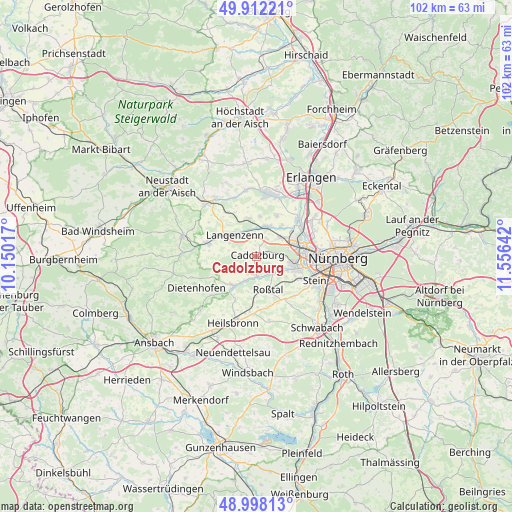
Cadolzburg GPS coordinates[2]
49° 27' 26.28" North, 10° 51' 11.844" East
| Map corner | latitude | longitude |
|---|---|---|
| Upper-left | 49.91221°, | 10.15017° |
| Center: | 49.4573°, | 10.85329° |
| Lower-right: | 48.99813°, | 11.55642° |
| Map W x H: | 101.6×101.6 km | = 63.1×63.1mi |
| max Lat: | 55.01917° ⇑76.4% North |
| Cadolzburg: | 49.4573° |
| min Lat: | ⇓23.6% South 47.40724° |
| min Long | Cadolzburg | max Long |
| 5.92978° | 10.85329° | 14.98853° |
| W 64.8%⇐ | ⇒35.2% E |
Elevation
Elevation of Cadolzburg is 381 m = 1250 ft, and this is 131.9 m = 433 ft above average elevation for this country.
| Max E: |
1256 m = 4121 ft | 27.2% |
| Cadolzburg | 381 m 1250 ft | |
| Avg. | 249.1 m = 817 ft | |
Min E: |
-5 m = -16 ft | 72.8% |
See also: Germany elevation on elevation.city.
Geographical zone
Cadolzburg is located in North temperate zone (between Tropic of Cancer and the Arctic Circle). Distance of this North polar circle is 1902 km =1181.8 mi to North.| Distance of | km | miles | from Cadolzburg |
|---|---|---|---|
| North Pole | 4507.9 | 2801.1 | to North |
| Arctic Circle | 1902 | 1181.8 | to North |
| Tropic Cancer | 2893.2 | 1797.8 | to South |
| Equator | 5499.1 | 3417 | to South |


Nearby cities:
15 places around Cadolzburg: (largest is in red/bold)
• Adelsdorf
12.2 km =7.6 mi,  276°
276°
• Ammerndorf
3.8 km =2.4 mi,  183°
183°
• Fürth
10 km =6.2 mi,  78°
78°
• Großhabersdorf
8.1 km =5 mi,  218°
218°
• Hagenbüchach
10.5 km =6.5 mi,  323°
323°
• Langenzenn
6.1 km =3.8 mi,  313°
313°
• Oberasbach
8.5 km =5.3 mi,  116°
116°
• Obermichelbach
9.1 km =5.7 mi,  26°
26°
• Puschendorf
7.6 km =4.7 mi,  348°
348°
• Roßtal
7.3 km =4.5 mi,  159°
159°
• Seukendorf
4 km =2.5 mi, 29°
• Tuchenbach
7.9 km =4.9 mi,  3°
3°
• Veitsbronn
6.6 km =4.1 mi,  22°
22°
• Wilhermsdorf
10.4 km =6.5 mi,  286°
286°
• Zirndorf
7.5 km =4.7 mi,  102°
102°
Sources, notices
• [Note1] Compared only with cities in Germany existing in our database
• [Src1] Map data: © OpenStreetMap contributors (CC-BY-SA)
• [Src2] Other city data from geonames.org with taken over terms of usage.
• [Src3] Geographical zone / Annual Mean Temperature by Robert A. Rohde @ Wikipedia
