Roßtal geodata
Roßtal (Bavaria) is a populated place; located in Germany in Europe/Berlin (GMT+2) time zone. With population of 10,052 people, there are 1630 cities with bigger population in this country. Compared to other cities in Germany, 77.3% of cities are located further ↑North; 65.4% of cities are located further ←West and 71.1% of cities have lower elevation than Roßtal. Note1
Administrative division(s):
- Level 1: Bavaria
- Level 2: Regierungsbezirk Mittelfranken
- Level 3: Landkreis Fürth
- Level 4: Roßtal, Markt


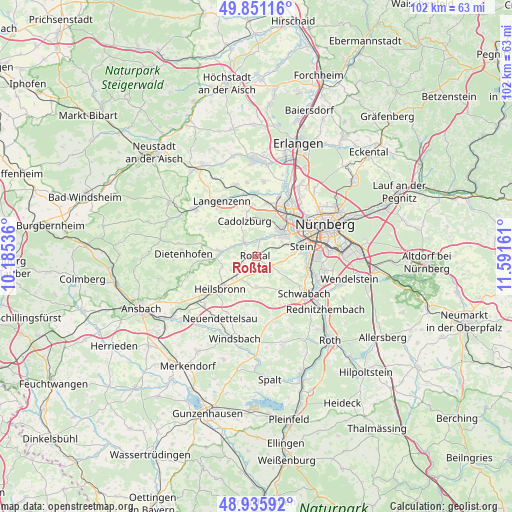
Roßtal GPS coordinates[2]
49° 23' 44.412" North, 10° 53' 18.528" East
| Map corner | latitude | longitude |
|---|---|---|
| Upper-left | 49.85116°, | 10.18536° |
| Center: | 49.39567°, | 10.88848° |
| Lower-right: | 48.93592°, | 11.59161° |
| Map W x H: | 101.8×101.8 km | = 63.3×63.3mi |
| max Lat: | 55.01917° ⇑77.3% North |
| Roßtal: | 49.39567° |
| min Lat: | ⇓22.7% South 47.40724° |
| min Long | Roßtal | max Long |
| 5.92978° | 10.88848° | 14.98853° |
| W 65.4%⇐ | ⇒34.6% E |
Elevation
Elevation of Roßtal is 367 m = 1204 ft, and this is 117.9 m = 387 ft above average elevation for this country.
| Max E: |
1256 m = 4121 ft | 28.9% |
| Roßtal | 367 m 1204 ft | |
| Avg. | 249.1 m = 817 ft | |
Min E: |
-5 m = -16 ft | 71.1% |
See also: Germany elevation on elevation.city.
Geographical zone
Roßtal is located in North temperate zone (between Tropic of Cancer and the Arctic Circle). Distance of this North polar circle is 1908.9 km =1186.1 mi to North.| Distance of | km | miles | from Roßtal |
|---|---|---|---|
| North Pole | 4514.8 | 2805.4 | to North |
| Arctic Circle | 1908.9 | 1186.1 | to North |
| Tropic Cancer | 2886.4 | 1793.5 | to South |
| Equator | 5492.3 | 3412.8 | to South |


Nearby cities:
15 places around Roßtal: (largest is in red/bold)
• Ammerndorf
4.1 km =2.5 mi,  317°
317°
• Cadolzburg
7.3 km =4.5 mi,  339°
339°
• Fürth
11.5 km =7.1 mi,  39°
39°
• Großhabersdorf
7.6 km =4.7 mi,  273°
273°
• Großreuth bei Schweinau
10.6 km =6.6 mi,  66°
66°
• Heilsbronn
9.9 km =6.2 mi,  227°
227°
• Kammerstein
12.9 km =8 mi,  151°
151°
• Langenzenn
13 km =8.1 mi,  327°
327°
• Oberasbach
5.8 km =3.6 mi,  58°
58°
• Rohr
6.1 km =3.8 mi,  179°
179°
• Schwabach
12.2 km =7.6 mi,  126°
126°
• Seukendorf
10.3 km =6.4 mi,  356°
356°
• Stein
9.5 km =5.9 mi,  76°
76°
• Veitsbronn
13 km =8.1 mi, 359°
• Zirndorf
7 km =4.3 mi, 42°
Sources, notices
• [Note1] Compared only with cities in Germany existing in our database
• [Src1] Map data: © OpenStreetMap contributors (CC-BY-SA)
• [Src2] Other city data from geonames.org with taken over terms of usage.
• [Src3] Geographical zone / Annual Mean Temperature by Robert A. Rohde @ Wikipedia
