Ziegelheim geodata
Ziegelheim (Thuringia) is a seat of a fourth-order administrative division; located in Germany in Europe/Berlin (GMT+2) time zone. With population of 959 people, there are 7312 cities with bigger population in this country. Compared to other cities in Germany, 56.8% of cities are located further ↓South; 88.3% of cities are located further ←West and 50.5% of cities have higher elevation than Ziegelheim. Note1


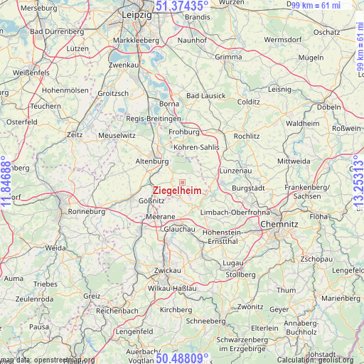
Ziegelheim GPS coordinates[2]
50° 55' 59.988" North, 12° 33' 0" East
| Map corner | latitude | longitude |
|---|---|---|
| Upper-left | 51.37435°, | 11.84688° |
| Center: | 50.93333°, | 12.55° |
| Lower-right: | 50.48809°, | 13.25313° |
| Map W x H: | 98.5×98.5 km | = 61.2×61.2mi |
| max Lat: | 55.01917° ⇑43.2% North |
| Ziegelheim: | 50.93333° |
| min Lat: | ⇓56.8% South 47.40724° |
| min Long | Ziegelheim | max Long |
| 5.92978° | 12.55° | 14.98853° |
| W 88.3%⇐ | ⇒11.7% E |
Elevation
Elevation of Ziegelheim is 221 m = 725 ft, and this is 28.1 m = 92 ft below average elevation for this country.
| Max E: |
1256 m = 4121 ft | 50.5% |
| Avg. | 249.1 m = 817 ft | |
| Ziegelheim | 221 m = 725 ft | |
Min E: |
-5 m = -16 ft | 49.5% |
See also: Germany elevation on elevation.city.
Geographical zone
Ziegelheim is located in North temperate zone (between Tropic of Cancer and the Arctic Circle). Distance of this North polar circle is 1737.9 km =1079.9 mi to North.| Distance of | km | miles | from Ziegelheim |
|---|---|---|---|
| North Pole | 4343.8 | 2699.1 | to North |
| Arctic Circle | 1737.9 | 1079.9 | to North |
| Tropic Cancer | 3057.3 | 1899.7 | to South |
| Equator | 5663.3 | 3519 | to South |


Nearby cities:
15 places around Ziegelheim: (largest is in red/bold)
• Altenburg
10 km =6.2 mi,  307°
307°
• Frohnsdorf
2.3 km =1.4 mi,  63°
63°
• Göpfersdorf
4 km =2.5 mi,  124°
124°
• Gößnitz
9.6 km =6 mi,  239°
239°
• Jückelberg
5.6 km =3.5 mi,  97°
97°
• Langenleuba-Niederhain
4 km =2.5 mi,  42°
42°
• Nobitz
6.5 km =4 mi,  316°
316°
• Oberwiera
4.9 km =3 mi,  184°
184°
• Penig
10.8 km =6.7 mi,  89°
89°
• Pfaffroda
8.4 km =5.2 mi,  197°
197°
• Remse
9.3 km =5.8 mi,  172°
172°
• Saara
9 km =5.6 mi,  269°
269°
• Schönberg
8.4 km =5.2 mi,  209°
209°
• Waldenburg
7.2 km =4.5 mi,  151°
151°
• Windischleuba
10.8 km =6.7 mi,  328°
328°
Sources, notices
• [Note1] Compared only with cities in Germany existing in our database
• [Src1] Map data: © OpenStreetMap contributors (CC-BY-SA)
• [Src2] Other city data from geonames.org with taken over terms of usage.
• [Src3] Geographical zone / Annual Mean Temperature by Robert A. Rohde @ Wikipedia
