Remse geodata
Remse (Saxony) is a seat of a fourth-order administrative division; located in Germany in Europe/Berlin (GMT+2) time zone. With population of 1,956 people, there are 5124 cities with bigger population in this country. Compared to other cities in Germany, 55% of cities are located further ↓South; 88.5% of cities are located further ←West and 54.3% of cities have lower elevation than Remse. Note1


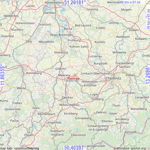
Remse GPS coordinates[2]
50° 51' 0" North, 12° 34' 0.012" East
| Map corner | latitude | longitude |
|---|---|---|
| Upper-left | 51.29181°, | 11.86355° |
| Center: | 50.85°, | 12.56667° |
| Lower-right: | 50.40397°, | 13.2698° |
| Map W x H: | 98.7×98.7 km | = 61.3×61.3mi |
| max Lat: | 55.01917° ⇑45% North |
| Remse: | 50.85° |
| min Lat: | ⇓55% South 47.40724° |
| min Long | Remse | max Long |
| 5.92978° | 12.56667° | 14.98853° |
| W 88.5%⇐ | ⇒11.5% E |
Elevation
Elevation of Remse is 254 m = 833 ft, and this is 4.9 m = 16 ft above average elevation for this country.
| Max E: |
1256 m = 4121 ft | 45.7% |
| Remse | 254 m 833 ft | |
| Avg. | 249.1 m = 817 ft | |
Min E: |
-5 m = -16 ft | 54.3% |
See also: Germany elevation on elevation.city.
Geographical zone
Remse is located in North temperate zone (between Tropic of Cancer and the Arctic Circle). Distance of this North polar circle is 1747.2 km =1085.7 mi to North.| Distance of | km | miles | from Remse |
|---|---|---|---|
| North Pole | 4353.1 | 2704.9 | to North |
| Arctic Circle | 1747.2 | 1085.7 | to North |
| Tropic Cancer | 3048.1 | 1894 | to South |
| Equator | 5654 | 3513.2 | to South |


Nearby cities:
15 places around Remse: (largest is in red/bold)
• Callenberg
4.7 km =2.9 mi,  90°
90°
• Dennheritz
8.2 km =5.1 mi,  240°
240°
• Frohnsdorf
10.3 km =6.4 mi,  4°
4°
• Glauchau
3.7 km =2.3 mi,  204°
204°
• Göpfersdorf
7.3 km =4.5 mi,  16°
16°
• Gößnitz
10.3 km =6.4 mi,  294°
294°
• Jückelberg
9.6 km =6 mi,  26°
26°
• Meerane
7.2 km =4.5 mi,  267°
267°
• Oberwiera
4.6 km =2.9 mi,  340°
340°
• Pfaffroda
3.8 km =2.4 mi, 289°
• Ponitz
10.1 km =6.3 mi, 274°
• Sankt Egidien
8.2 km =5.1 mi,  150°
150°
• Schönberg
5.6 km =3.5 mi, 290°
• Waldenburg
3.7 km =2.3 mi,  37°
37°
• Ziegelheim
9.3 km =5.8 mi,  352°
352°
Sources, notices
• [Note1] Compared only with cities in Germany existing in our database
• [Src1] Map data: © OpenStreetMap contributors (CC-BY-SA)
• [Src2] Other city data from geonames.org with taken over terms of usage.
• [Src3] Geographical zone / Annual Mean Temperature by Robert A. Rohde @ Wikipedia
