Frohnsdorf geodata
Frohnsdorf (Thuringia) is a seat of a fourth-order administrative division; located in Germany in Europe/Berlin (GMT+2) time zone. With population of 334 people, there are 9927 cities with bigger population in this country. Compared to other cities in Germany, 57% of cities are located further ↓South; 88.6% of cities are located further ←West and 52.1% of cities have higher elevation than Frohnsdorf. Note1


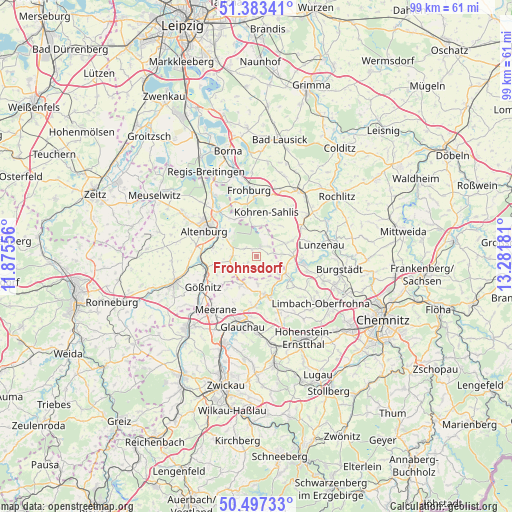
Frohnsdorf GPS coordinates[2]
50° 56' 32.928" North, 12° 34' 43.248" East
| Map corner | latitude | longitude |
|---|---|---|
| Upper-left | 51.38341°, | 11.87556° |
| Center: | 50.94248°, | 12.57868° |
| Lower-right: | 50.49733°, | 13.28181° |
| Map W x H: | 98.5×98.5 km | = 61.2×61.2mi |
| max Lat: | 55.01917° ⇑43% North |
| Frohnsdorf: | 50.94248° |
| min Lat: | ⇓57% South 47.40724° |
| min Long | Frohnsdorf | max Long |
| 5.92978° | 12.57868° | 14.98853° |
| W 88.6%⇐ | ⇒11.4% E |
Elevation
Elevation of Frohnsdorf is 211 m = 692 ft, and this is 38.1 m = 125 ft below average elevation for this country.
| Max E: |
1256 m = 4121 ft | 52.1% |
| Avg. | 249.1 m = 817 ft | |
| Frohnsdorf | 211 m = 692 ft | |
Min E: |
-5 m = -16 ft | 47.9% |
See also: Germany elevation on elevation.city.
Geographical zone
Frohnsdorf is located in North temperate zone (between Tropic of Cancer and the Arctic Circle). Distance of this North polar circle is 1736.9 km =1079.3 mi to North.| Distance of | km | miles | from Frohnsdorf |
|---|---|---|---|
| North Pole | 4342.8 | 2698.5 | to North |
| Arctic Circle | 1736.9 | 1079.3 | to North |
| Tropic Cancer | 3058.4 | 1900.4 | to South |
| Equator | 5664.3 | 3519.6 | to South |


Nearby cities:
15 places around Frohnsdorf: (largest is in red/bold)
• Altenburg
11.1 km =6.9 mi,  296°
296°
• Callenberg
11 km =6.8 mi,  159°
159°
• Göpfersdorf
3.5 km =2.2 mi, 159°
• Jückelberg
3.9 km =2.4 mi,  116°
116°
• Langenleuba-Niederhain
2.1 km =1.3 mi,  19°
19°
• Niederfrohna
10.8 km =6.7 mi, 116°
• Nobitz
7.5 km =4.7 mi, 300°
• Oberwiera
6.4 km =4 mi,  202°
202°
• Penig
8.9 km =5.5 mi,  96°
96°
• Pfaffroda
10.1 km =6.3 mi,  206°
206°
• Remse
10.3 km =6.4 mi,  184°
184°
• Saara
11.1 km =6.9 mi,  264°
264°
• Schönberg
10.3 km =6.4 mi,  216°
216°
• Waldenburg
7.5 km =4.7 mi,  168°
168°
• Ziegelheim
2.3 km =1.4 mi,  243°
243°
Sources, notices
• [Note1] Compared only with cities in Germany existing in our database
• [Src1] Map data: © OpenStreetMap contributors (CC-BY-SA)
• [Src2] Other city data from geonames.org with taken over terms of usage.
• [Src3] Geographical zone / Annual Mean Temperature by Robert A. Rohde @ Wikipedia
