Waldenburg geodata
Waldenburg (Saxony) is a populated place; located in Germany in Europe/Berlin (GMT+2) time zone. With population of 4,597 people, there are 2987 cities with bigger population in this country. Compared to other cities in Germany, 55.7% of cities are located further ↓South; 88.8% of cities are located further ←West and 56.2% of cities have lower elevation than Waldenburg. Note1


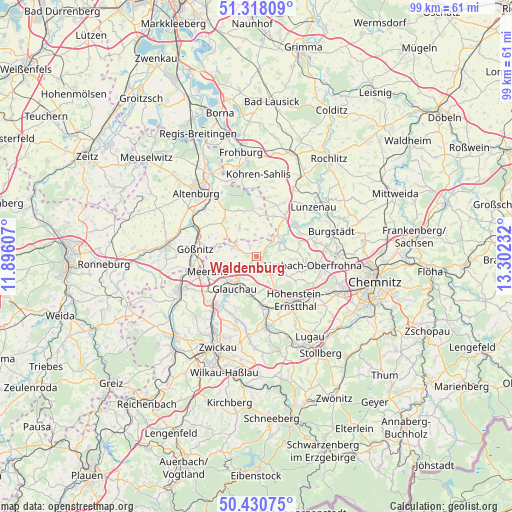
Waldenburg GPS coordinates[2]
50° 52' 35.508" North, 12° 35' 57.084" East
| Map corner | latitude | longitude |
|---|---|---|
| Upper-left | 51.31809°, | 11.89607° |
| Center: | 50.87653°, | 12.59919° |
| Lower-right: | 50.43075°, | 13.30232° |
| Map W x H: | 98.7×98.7 km | = 61.3×61.3mi |
| max Lat: | 55.01917° ⇑44.3% North |
| Waldenburg: | 50.87653° |
| min Lat: | ⇓55.7% South 47.40724° |
| min Long | Waldenburg | max Long |
| 5.92978° | 12.59919° | 14.98853° |
| W 88.8%⇐ | ⇒11.2% E |
Elevation
Elevation of Waldenburg is 267 m = 876 ft, and this is 17.9 m = 59 ft above average elevation for this country.
| Max E: |
1256 m = 4121 ft | 43.8% |
| Waldenburg | 267 m 876 ft | |
| Avg. | 249.1 m = 817 ft | |
Min E: |
-5 m = -16 ft | 56.2% |
See also: Germany elevation on elevation.city.
Geographical zone
Waldenburg is located in North temperate zone (between Tropic of Cancer and the Arctic Circle). Distance of this North polar circle is 1744.2 km =1083.8 mi to North.| Distance of | km | miles | from Waldenburg |
|---|---|---|---|
| North Pole | 4350.1 | 2703 | to North |
| Arctic Circle | 1744.2 | 1083.8 | to North |
| Tropic Cancer | 3051 | 1895.8 | to South |
| Equator | 5656.9 | 3515 | to South |


Nearby cities:
15 places around Waldenburg: (largest is in red/bold)
• Callenberg
3.8 km =2.4 mi,  140°
140°
• Frohnsdorf
7.5 km =4.7 mi,  348°
348°
• Glauchau
7.4 km =4.6 mi,  211°
211°
• Göpfersdorf
4.1 km =2.5 mi,  357°
357°
• Jückelberg
6 km =3.7 mi,  20°
20°
• Langenleuba-Niederhain
9.3 km =5.8 mi, 355°
• Meerane
10 km =6.2 mi,  250°
250°
• Niederfrohna
8.6 km =5.3 mi,  72°
72°
• Oberwiera
4.1 km =2.5 mi,  289°
289°
• Penig
9.7 km =6 mi,  49°
49°
• Pfaffroda
6.1 km =3.8 mi, 254°
• Remse
3.7 km =2.3 mi,  217°
217°
• Sankt Egidien
10.2 km =6.3 mi,  170°
170°
• Schönberg
7.6 km =4.7 mi,  262°
262°
• Ziegelheim
7.2 km =4.5 mi,  331°
331°
Sources, notices
• [Note1] Compared only with cities in Germany existing in our database
• [Src1] Map data: © OpenStreetMap contributors (CC-BY-SA)
• [Src2] Other city data from geonames.org with taken over terms of usage.
• [Src3] Geographical zone / Annual Mean Temperature by Robert A. Rohde @ Wikipedia
