Pfaffroda geodata
Pfaffroda (Saxony) is a populated place; located in Germany in Europe/Berlin (GMT+2) time zone. With population of 3,187 people, there are 3836 cities with bigger population in this country. Compared to other cities in Germany, 55.4% of cities are located further ↓South; 88.1% of cities are located further ←West and 61.2% of cities have lower elevation than Pfaffroda. Note1


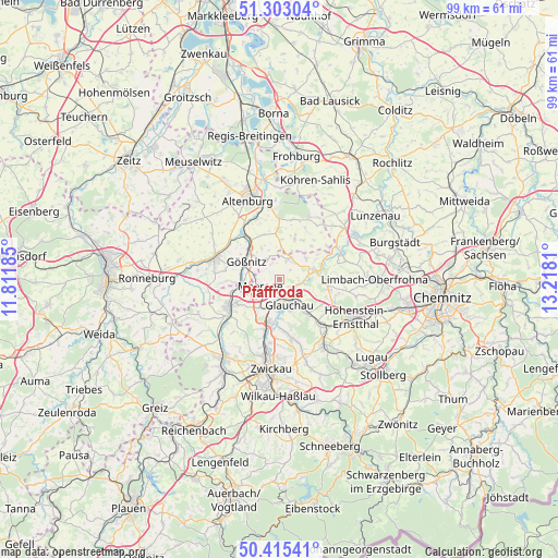
Pfaffroda GPS coordinates[2]
50° 51' 40.824" North, 12° 30' 53.892" East
| Map corner | latitude | longitude |
|---|---|---|
| Upper-left | 51.30304°, | 11.81185° |
| Center: | 50.86134°, | 12.51497° |
| Lower-right: | 50.41541°, | 13.2181° |
| Map W x H: | 98.7×98.7 km | = 61.3×61.3mi |
| max Lat: | 55.01917° ⇑44.6% North |
| Pfaffroda: | 50.86134° |
| min Lat: | ⇓55.4% South 47.40724° |
| min Long | Pfaffroda | max Long |
| 5.92978° | 12.51497° | 14.98853° |
| W 88.1%⇐ | ⇒11.9% E |
Elevation
Elevation of Pfaffroda is 297 m = 974 ft, and this is 47.9 m = 157 ft above average elevation for this country.
| Max E: |
1256 m = 4121 ft | 38.8% |
| Pfaffroda | 297 m 974 ft | |
| Avg. | 249.1 m = 817 ft | |
Min E: |
-5 m = -16 ft | 61.2% |
See also: Germany elevation on elevation.city.
Geographical zone
Pfaffroda is located in North temperate zone (between Tropic of Cancer and the Arctic Circle). Distance of this North polar circle is 1745.9 km =1084.9 mi to North.| Distance of | km | miles | from Pfaffroda |
|---|---|---|---|
| North Pole | 4351.8 | 2704.1 | to North |
| Arctic Circle | 1745.9 | 1084.9 | to North |
| Tropic Cancer | 3049.3 | 1894.7 | to South |
| Equator | 5655.3 | 3514 | to South |


Nearby cities:
15 places around Pfaffroda: (largest is in red/bold)
• Callenberg
8.4 km =5.2 mi,  98°
98°
• Crimmitschau
10.1 km =6.3 mi,  240°
240°
• Dennheritz
6.3 km =3.9 mi,  213°
213°
• Frohnsdorf
10.1 km =6.3 mi,  26°
26°
• Glauchau
5.1 km =3.2 mi,  155°
155°
• Göpfersdorf
8.1 km =5 mi,  44°
44°
• Gößnitz
6.5 km =4 mi,  298°
298°
• Meerane
3.9 km =2.4 mi,  245°
245°
• Oberwiera
3.7 km =2.3 mi, 33°
• Ponitz
6.5 km =4 mi,  266°
266°
• Remse
3.8 km =2.4 mi,  109°
109°
• Saara
10.3 km =6.4 mi,  320°
320°
• Schönberg
1.8 km =1.1 mi,  292°
292°
• Waldenburg
6.1 km =3.8 mi,  74°
74°
• Ziegelheim
8.4 km =5.2 mi,  17°
17°
Sources, notices
• [Note1] Compared only with cities in Germany existing in our database
• [Src1] Map data: © OpenStreetMap contributors (CC-BY-SA)
• [Src2] Other city data from geonames.org with taken over terms of usage.
• [Src3] Geographical zone / Annual Mean Temperature by Robert A. Rohde @ Wikipedia
