Zangberg geodata
Zangberg (Bavaria) is a seat of a fourth-order administrative division; located in Germany in Europe/Berlin (GMT+2) time zone. With population of 1,021 people, there are 7109 cities with bigger population in this country. Compared to other cities in Germany, 91.6% of cities are located further ↑North; 87.2% of cities are located further ←West and 77.9% of cities have lower elevation than Zangberg. Note1
Administrative division(s):
- Level 1: Bavaria
- Level 2: Upper Bavaria
- Level 3: Landkreis Mühldorf am Inn
- Level 4: Zangberg


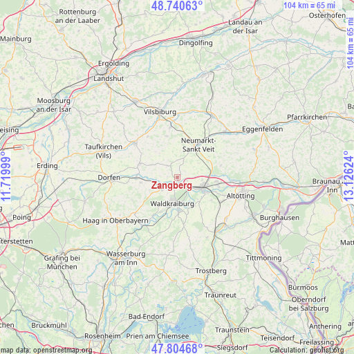
Zangberg GPS coordinates[2]
48° 16' 29.28" North, 12° 25' 23.196" East
| Map corner | latitude | longitude |
|---|---|---|
| Upper-left | 48.74063°, | 11.71999° |
| Center: | 48.2748°, | 12.42311° |
| Lower-right: | 47.80468°, | 13.12624° |
| Map W x H: | 104.1×104.1 km | = 64.7×64.7mi |
| max Lat: | 55.01917° ⇑91.6% North |
| Zangberg: | 48.2748° |
| min Lat: | ⇓8.4% South 47.40724° |
| min Long | Zangberg | max Long |
| 5.92978° | 12.42311° | 14.98853° |
| W 87.2%⇐ | ⇒12.8% E |
Elevation
Elevation of Zangberg is 418 m = 1371 ft, and this is 168.9 m = 554 ft above average elevation for this country.
| Max E: |
1256 m = 4121 ft | 22.1% |
| Zangberg | 418 m 1371 ft | |
| Avg. | 249.1 m = 817 ft | |
Min E: |
-5 m = -16 ft | 77.9% |
See also: Germany elevation on elevation.city.
Geographical zone
Zangberg is located in North temperate zone (between Tropic of Cancer and the Arctic Circle). Distance of this North polar circle is 2033.5 km =1263.6 mi to North.| Distance of | km | miles | from Zangberg |
|---|---|---|---|
| North Pole | 4639.4 | 2882.8 | to North |
| Arctic Circle | 2033.5 | 1263.6 | to North |
| Tropic Cancer | 2761.7 | 1716 | to South |
| Equator | 5367.7 | 3335.3 | to South |


Nearby cities:
15 places around Zangberg: (largest is in red/bold)
• Ampfing
2.4 km =1.5 mi,  194°
194°
• Aschau am Inn
10.1 km =6.3 mi,  212°
212°
• Kraiburg am Inn
10.3 km =6.4 mi,  176°
176°
• Lohkirchen
5.1 km =3.2 mi,  23°
23°
• Mettenheim
3.3 km =2.1 mi,  105°
105°
• Mühldorf
7.9 km =4.9 mi, 113°
• Neufahrn
2.5 km =1.6 mi,  148°
148°
• Niederbergkirchen
7.4 km =4.6 mi,  50°
50°
• Oberbergkirchen
4.1 km =2.5 mi,  313°
313°
• Obertaufkirchen
10.8 km =6.7 mi,  261°
261°
• Rattenkirchen
8.8 km =5.5 mi,  245°
245°
• Rohrbach
10 km =6.2 mi,  80°
80°
• Schönberg
6.6 km =4.1 mi,  6°
6°
• Waldkraiburg
7.6 km =4.7 mi, 193°
• Wurmsham
10.7 km =6.6 mi,  321°
321°
Sources, notices
• [Note1] Compared only with cities in Germany existing in our database
• [Src1] Map data: © OpenStreetMap contributors (CC-BY-SA)
• [Src2] Other city data from geonames.org with taken over terms of usage.
• [Src3] Geographical zone / Annual Mean Temperature by Robert A. Rohde @ Wikipedia
