Ampfing geodata
Ampfing (Bavaria) is a seat of a fourth-order administrative division; located in Germany in Europe/Berlin (GMT+2) time zone. With population of 6,188 people, there are 2405 cities with bigger population in this country. Compared to other cities in Germany, 91.9% of cities are located further ↑North; 87.1% of cities are located further ←West and 77.9% of cities have lower elevation than Ampfing. Note1
Administrative division(s):
- Level 1: Bavaria
- Level 2: Upper Bavaria
- Level 3: Landkreis Mühldorf am Inn
- Level 4: Ampfing


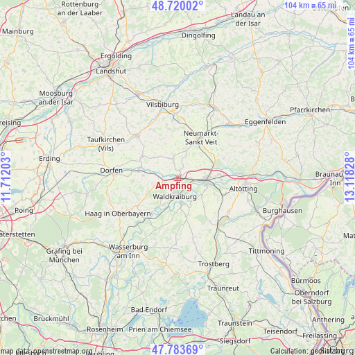
Ampfing GPS coordinates[2]
48° 15' 14.4" North, 12° 24' 54.54" East
| Map corner | latitude | longitude |
|---|---|---|
| Upper-left | 48.72002°, | 11.71203° |
| Center: | 48.254°, | 12.41515° |
| Lower-right: | 47.78369°, | 13.11828° |
| Map W x H: | 104.1×104.1 km | = 64.7×64.7mi |
| max Lat: | 55.01917° ⇑91.9% North |
| Ampfing: | 48.254° |
| min Lat: | ⇓8.1% South 47.40724° |
| min Long | Ampfing | max Long |
| 5.92978° | 12.41515° | 14.98853° |
| W 87.1%⇐ | ⇒12.9% E |
Elevation
Elevation of Ampfing is 418 m = 1371 ft, and this is 168.9 m = 554 ft above average elevation for this country.
| Max E: |
1256 m = 4121 ft | 22.1% |
| Ampfing | 418 m 1371 ft | |
| Avg. | 249.1 m = 817 ft | |
Min E: |
-5 m = -16 ft | 77.9% |
See also: Germany elevation on elevation.city.
Geographical zone
Ampfing is located in North temperate zone (between Tropic of Cancer and the Arctic Circle). Distance of this North polar circle is 2035.8 km =1265 mi to North.| Distance of | km | miles | from Ampfing |
|---|---|---|---|
| North Pole | 4641.7 | 2884.2 | to North |
| Arctic Circle | 2035.8 | 1265 | to North |
| Tropic Cancer | 2759.4 | 1714.6 | to South |
| Equator | 5365.3 | 3333.8 | to South |


Nearby cities:
15 places around Ampfing: (largest is in red/bold)
• Aschau am Inn
7.8 km =4.8 mi,  217°
217°
• Jettenbach
10 km =6.2 mi,  193°
193°
• Kraiburg am Inn
8.1 km =5 mi,  171°
171°
• Lohkirchen
7.4 km =4.6 mi,  20°
20°
• Mettenheim
4.1 km =2.5 mi,  69°
69°
• Mühldorf
7.9 km =4.9 mi,  95°
95°
• Neufahrn
1.9 km =1.2 mi,  83°
83°
• Niederbergkirchen
9.4 km =5.8 mi,  42°
42°
• Oberbergkirchen
5.6 km =3.5 mi,  335°
335°
• Oberneukirchen
10.9 km =6.8 mi,  136°
136°
• Obertaufkirchen
10.1 km =6.3 mi,  274°
274°
• Rattenkirchen
7.5 km =4.7 mi,  259°
259°
• Schönberg
8.9 km =5.5 mi,  8°
8°
• Waldkraiburg
5.2 km =3.2 mi, 193°
• Zangberg
2.4 km =1.5 mi, 14°
Sources, notices
• [Note1] Compared only with cities in Germany existing in our database
• [Src1] Map data: © OpenStreetMap contributors (CC-BY-SA)
• [Src2] Other city data from geonames.org with taken over terms of usage.
• [Src3] Geographical zone / Annual Mean Temperature by Robert A. Rohde @ Wikipedia
