Aschau am Inn geodata
Aschau am Inn (Bavaria) is a populated place; located in Germany in Europe/Berlin (GMT+2) time zone. With population of 2,907 people, there are 4085 cities with bigger population in this country. Compared to other cities in Germany, 92.7% of cities are located further ↑North; 86.4% of cities are located further ←West and 83.4% of cities have lower elevation than Aschau am Inn. Note1
Administrative division(s):
- Level 1: Bavaria
- Level 2: Upper Bavaria
- Level 3: Landkreis Mühldorf am Inn
- Level 4: Aschau a.Inn


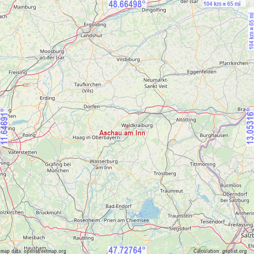
Aschau am Inn GPS coordinates[2]
48° 11' 54.42" North, 12° 21' 0.108" East
| Map corner | latitude | longitude |
|---|---|---|
| Upper-left | 48.66498°, | 11.64691° |
| Center: | 48.19845°, | 12.35003° |
| Lower-right: | 47.72764°, | 13.05316° |
| Map W x H: | 104.2×104.2 km | = 64.7×64.7mi |
| max Lat: | 55.01917° ⇑92.7% North |
| Aschau am Inn: | 48.19845° |
| min Lat: | ⇓7.3% South 47.40724° |
| min Long | Aschau am Inn | max Long |
| 5.92978° | 12.35003° | 14.98853° |
| W 86.4%⇐ | ⇒13.6% E |
Elevation
Elevation of Aschau am Inn is 457 m = 1499 ft, and this is 207.9 m = 682 ft above average elevation for this country.
| Max E: |
1256 m = 4121 ft | 16.6% |
| Aschau am Inn | 457 m 1499 ft | |
| Avg. | 249.1 m = 817 ft | |
Min E: |
-5 m = -16 ft | 83.4% |
See also: Germany elevation on elevation.city.
Geographical zone
Aschau am Inn is located in North temperate zone (between Tropic of Cancer and the Arctic Circle). Distance of this North polar circle is 2042 km =1268.8 mi to North.| Distance of | km | miles | from Aschau am Inn |
|---|---|---|---|
| North Pole | 4647.9 | 2888.1 | to North |
| Arctic Circle | 2042 | 1268.8 | to North |
| Tropic Cancer | 2753.2 | 1710.8 | to South |
| Equator | 5359.2 | 3330.1 | to South |


Nearby cities:
15 places around Aschau am Inn: (largest is in red/bold)
• Ampfing
7.8 km =4.8 mi,  37°
37°
• Gars
7.3 km =4.5 mi,  227°
227°
• Jettenbach
4.3 km =2.7 mi,  145°
145°
• Kraiburg am Inn
6.3 km =3.9 mi,  107°
107°
• Mettenheim
11.5 km =7.1 mi,  48°
48°
• Neufahrn
9.3 km =5.8 mi, 46°
• Obertaufkirchen
8.7 km =5.4 mi,  322°
322°
• Ramsau
9.4 km =5.8 mi,  252°
252°
• Rattenkirchen
5.5 km =3.4 mi,  331°
331°
• Reichertsheim
4.9 km =3 mi,  271°
271°
• Schwindegg
10.5 km =6.5 mi, 320°
• Taufkirchen
9.2 km =5.7 mi,  126°
126°
• Unterreit
9.2 km =5.7 mi,  187°
187°
• Waldkraiburg
3.8 km =2.4 mi,  72°
72°
• Zangberg
10.1 km =6.3 mi,  32°
32°
Sources, notices
• [Note1] Compared only with cities in Germany existing in our database
• [Src1] Map data: © OpenStreetMap contributors (CC-BY-SA)
• [Src2] Other city data from geonames.org with taken over terms of usage.
• [Src3] Geographical zone / Annual Mean Temperature by Robert A. Rohde @ Wikipedia
