Waldkraiburg geodata
Waldkraiburg (Bavaria) is a populated place; located in Germany in Europe/Berlin (GMT+2) time zone. With population of 24,676 people, there are 599 cities with bigger population in this country. Compared to other cities in Germany, 92.6% of cities are located further ↑North; 86.9% of cities are located further ←West and 80.9% of cities have lower elevation than Waldkraiburg. Note1
Administrative division(s):
- Level 1: Bavaria
- Level 2: Upper Bavaria
- Level 3: Landkreis Mühldorf am Inn
- Level 4: Waldkraiburg


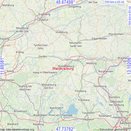
Waldkraiburg GPS coordinates[2]
48° 12' 30.744" North, 12° 23' 56.148" East
| Map corner | latitude | longitude |
|---|---|---|
| Upper-left | 48.67498°, | 11.69581° |
| Center: | 48.20854°, | 12.39893° |
| Lower-right: | 47.73782°, | 13.10206° |
| Map W x H: | 104.2×104.2 km | = 64.7×64.7mi |
| max Lat: | 55.01917° ⇑92.6% North |
| Waldkraiburg: | 48.20854° |
| min Lat: | ⇓7.4% South 47.40724° |
| min Long | Waldkraiburg | max Long |
| 5.92978° | 12.39893° | 14.98853° |
| W 86.9%⇐ | ⇒13.1% E |
Elevation
Elevation of Waldkraiburg is 439 m = 1440 ft, and this is 189.9 m = 623 ft above average elevation for this country.
| Max E: |
1256 m = 4121 ft | 19.1% |
| Waldkraiburg | 439 m 1440 ft | |
| Avg. | 249.1 m = 817 ft | |
Min E: |
-5 m = -16 ft | 80.9% |
See also: Germany elevation on elevation.city.
Geographical zone
Waldkraiburg is located in North temperate zone (between Tropic of Cancer and the Arctic Circle). Distance of this North polar circle is 2040.9 km =1268.2 mi to North.| Distance of | km | miles | from Waldkraiburg |
|---|---|---|---|
| North Pole | 4646.8 | 2887.4 | to North |
| Arctic Circle | 2040.9 | 1268.2 | to North |
| Tropic Cancer | 2754.4 | 1711.5 | to South |
| Equator | 5360.3 | 3330.7 | to South |


Nearby cities:
15 places around Waldkraiburg: (largest is in red/bold)
• Ampfing
5.2 km =3.2 mi,  13°
13°
• Aschau am Inn
3.8 km =2.4 mi,  252°
252°
• Gars
10.9 km =6.8 mi,  235°
235°
• Jettenbach
4.8 km =3 mi,  193°
193°
• Kraiburg am Inn
3.8 km =2.4 mi,  141°
141°
• Mettenheim
8.2 km =5.1 mi,  37°
37°
• Mühldorf
10 km =6.2 mi,  64°
64°
• Neufahrn
6.1 km =3.8 mi,  30°
30°
• Oberbergkirchen
10.2 km =6.3 mi,  353°
353°
• Oberneukirchen
9.2 km =5.7 mi,  107°
107°
• Obertaufkirchen
10.6 km =6.6 mi,  303°
303°
• Rattenkirchen
7.2 km =4.5 mi, 300°
• Reichertsheim
8.6 km =5.3 mi,  263°
263°
• Taufkirchen
7.5 km =4.7 mi,  149°
149°
• Zangberg
7.6 km =4.7 mi, 13°
Sources, notices
• [Note1] Compared only with cities in Germany existing in our database
• [Src1] Map data: © OpenStreetMap contributors (CC-BY-SA)
• [Src2] Other city data from geonames.org with taken over terms of usage.
• [Src3] Geographical zone / Annual Mean Temperature by Robert A. Rohde @ Wikipedia
