Wörth an der Donau geodata
Wörth an der Donau (Bavaria) is a populated place; located in Germany in Europe/Berlin (GMT+2) time zone. With population of 4,524 people, there are 3028 cities with bigger population in this country. Compared to other cities in Germany, 83% of cities are located further ↑North; 87% of cities are located further ←West and 68.1% of cities have lower elevation than Wörth an der Donau. Note1
Administrative division(s):
- Level 1: Bavaria
- Level 2: Upper Palatinate
- Level 3: Landkreis Regensburg
- Level 4: Wörth a.d.Donau


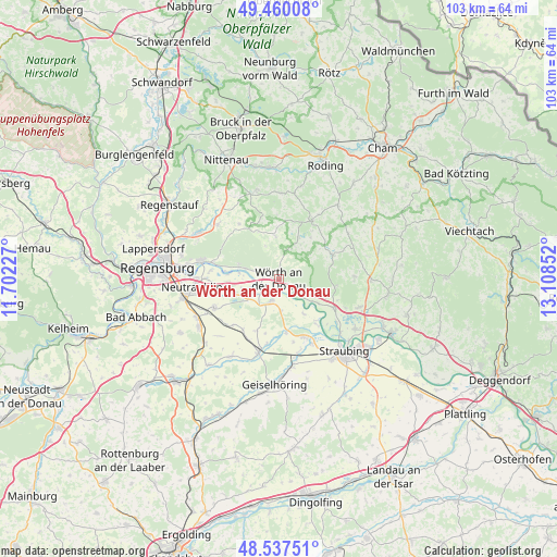
Wörth an der Donau GPS coordinates[2]
49° 0' 3.348" North, 12° 24' 19.404" East
| Map corner | latitude | longitude |
|---|---|---|
| Upper-left | 49.46008°, | 11.70227° |
| Center: | 49.00093°, | 12.40539° |
| Lower-right: | 48.53751°, | 13.10852° |
| Map W x H: | 102.6×102.6 km | = 63.8×63.8mi |
| max Lat: | 55.01917° ⇑83% North |
| Wörth an der Donau: | 49.00093° |
| min Lat: | ⇓17% South 47.40724° |
| min Long | Wörth an der D | max Long |
| 5.92978° | 12.40539° | 14.98853° |
| W 87%⇐ | ⇒13% E |
Elevation
Elevation of Wörth an der Donau is 343 m = 1125 ft, and this is 93.9 m = 308 ft above average elevation for this country.
| Max E: |
1256 m = 4121 ft | 31.9% |
| Wörth an der Donau | 343 m 1125 ft | |
| Avg. | 249.1 m = 817 ft | |
Min E: |
-5 m = -16 ft | 68.1% |
See also: Germany elevation on elevation.city.
Geographical zone
Wörth an der Donau is located in North temperate zone (between Tropic of Cancer and the Arctic Circle). Distance of this North polar circle is 1952.8 km =1213.4 mi to North.| Distance of | km | miles | from Wörth an der Donau |
|---|---|---|---|
| North Pole | 4558.7 | 2832.6 | to North |
| Arctic Circle | 1952.8 | 1213.4 | to North |
| Tropic Cancer | 2842.5 | 1766.2 | to South |
| Equator | 5448.4 | 3385.5 | to South |


Nearby cities:
15 places around Wörth an der Donau: (largest is in red/bold)
• Aholfing
7.9 km =4.9 mi,  144°
144°
• Altenthann
13.4 km =8.3 mi,  325°
325°
• Atting
13.3 km =8.3 mi,  153°
153°
• Brennberg
7.3 km =4.5 mi,  356°
356°
• Falkenfels
13.8 km =8.6 mi,  88°
88°
• Falkenstein
12.3 km =7.6 mi,  29°
29°
• Kirchroth
12 km =7.5 mi,  118°
118°
• Mintraching
13 km =8.1 mi,  246°
246°
• Mötzing
12.2 km =7.6 mi,  190°
190°
• Pfatter
4.5 km =2.8 mi,  201°
201°
• Rain
11.6 km =7.2 mi,  156°
156°
• Rettenbach
8 km =5 mi,  23°
23°
• Riekofen
10.2 km =6.3 mi, 203°
• Wiesenfelden
10.8 km =6.7 mi,  65°
65°
• Wiesent
2.4 km =1.5 mi,  317°
317°
Sources, notices
• [Note1] Compared only with cities in Germany existing in our database
• [Src1] Map data: © OpenStreetMap contributors (CC-BY-SA)
• [Src2] Other city data from geonames.org with taken over terms of usage.
• [Src3] Geographical zone / Annual Mean Temperature by Robert A. Rohde @ Wikipedia
