Falkenstein geodata
Falkenstein (Bavaria) is a populated place; located in Germany in Europe/Berlin (GMT+2) time zone. With population of 3,354 people, there are 3718 cities with bigger population in this country. Compared to other cities in Germany, 81.8% of cities are located further ↑North; 87.9% of cities are located further ←West and 93.5% of cities have lower elevation than Falkenstein. Note1
Administrative division(s):
- Level 1: Bavaria
- Level 2: Upper Palatinate
- Level 3: Landkreis Cham
- Level 4: Falkenstein, Markt


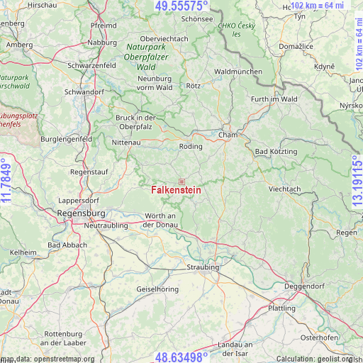
Falkenstein GPS coordinates[2]
49° 5' 51" North, 12° 29' 16.872" East
| Map corner | latitude | longitude |
|---|---|---|
| Upper-left | 49.55575°, | 11.7849° |
| Center: | 49.0975°, | 12.48802° |
| Lower-right: | 48.63498°, | 13.19115° |
| Map W x H: | 102.4×102.4 km | = 63.6×63.6mi |
| max Lat: | 55.01917° ⇑81.8% North |
| Falkenstein: | 49.0975° |
| min Lat: | ⇓18.2% South 47.40724° |
| min Long | Falkenstein | max Long |
| 5.92978° | 12.48802° | 14.98853° |
| W 87.9%⇐ | ⇒12.1% E |
Elevation
Elevation of Falkenstein is 566 m = 1857 ft, and this is 316.9 m = 1040 ft above average elevation for this country.
| Max E: |
1256 m = 4121 ft | 6.5% |
| Falkenstein | 566 m 1857 ft | |
| Avg. | 249.1 m = 817 ft | |
Min E: |
-5 m = -16 ft | 93.5% |
See also: Germany elevation on elevation.city.
Geographical zone
Falkenstein is located in North temperate zone (between Tropic of Cancer and the Arctic Circle). Distance of this North polar circle is 1942 km =1206.7 mi to North.| Distance of | km | miles | from Falkenstein |
|---|---|---|---|
| North Pole | 4547.9 | 2825.9 | to North |
| Arctic Circle | 1942 | 1206.7 | to North |
| Tropic Cancer | 2853.2 | 1772.9 | to South |
| Equator | 5459.1 | 3392.1 | to South |


Nearby cities:
15 places around Falkenstein: (largest is in red/bold)
• Altenthann
13.7 km =8.5 mi,  271°
271°
• Brennberg
7.3 km =4.5 mi,  241°
241°
• Falkenfels
13 km =8.1 mi,  143°
143°
• Loitzendorf
12.3 km =7.6 mi,  96°
96°
• Michelsneukirchen
5.5 km =3.4 mi,  59°
59°
• Rettenbach
4.4 km =2.7 mi,  218°
218°
• Roding
11 km =6.8 mi,  12°
12°
• Schorndorf
10.4 km =6.5 mi,  47°
47°
• Stallwang
13.2 km =8.2 mi,  113°
113°
• Traitsching
13.2 km =8.2 mi, 63°
• Wald
11.6 km =7.2 mi,  300°
300°
• Walderbach
12.2 km =7.6 mi,  321°
321°
• Wiesenfelden
7.4 km =4.6 mi,  149°
149°
• Wiesent
11.8 km =7.3 mi, 220°
• Wörth an der Donau
12.3 km =7.6 mi,  209°
209°
Sources, notices
• [Note1] Compared only with cities in Germany existing in our database
• [Src1] Map data: © OpenStreetMap contributors (CC-BY-SA)
• [Src2] Other city data from geonames.org with taken over terms of usage.
• [Src3] Geographical zone / Annual Mean Temperature by Robert A. Rohde @ Wikipedia
