Altenthann geodata
Altenthann (Bavaria) is a seat of a fourth-order administrative division; located in Germany in Europe/Berlin (GMT+2) time zone. With population of 1,607 people, there are 5671 cities with bigger population in this country. Compared to other cities in Germany, 81.7% of cities are located further ↑North; 85.8% of cities are located further ←West and 88.4% of cities have lower elevation than Altenthann. Note1
Administrative division(s):
- Level 1: Bavaria
- Level 2: Upper Palatinate
- Level 3: Landkreis Regensburg
- Level 4: Altenthann


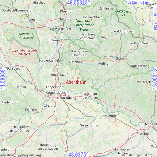
Altenthann GPS coordinates[2]
49° 6' 0" North, 12° 18' 0" East
| Map corner | latitude | longitude |
|---|---|---|
| Upper-left | 49.55823°, | 11.59688° |
| Center: | 49.1°, | 12.3° |
| Lower-right: | 48.6375°, | 13.00313° |
| Map W x H: | 102.4×102.4 km | = 63.6×63.6mi |
| max Lat: | 55.01917° ⇑81.7% North |
| Altenthann: | 49.1° |
| min Lat: | ⇓18.3% South 47.40724° |
| min Long | Altenthann | max Long |
| 5.92978° | 12.3° | 14.98853° |
| W 85.8%⇐ | ⇒14.2% E |
Elevation
Elevation of Altenthann is 498 m = 1634 ft, and this is 248.9 m = 817 ft above average elevation for this country.
| Max E: |
1256 m = 4121 ft | 11.6% |
| Altenthann | 498 m 1634 ft | |
| Avg. | 249.1 m = 817 ft | |
Min E: |
-5 m = -16 ft | 88.4% |
See also: Germany elevation on elevation.city.
Geographical zone
Altenthann is located in North temperate zone (between Tropic of Cancer and the Arctic Circle). Distance of this North polar circle is 1941.8 km =1206.6 mi to North.| Distance of | km | miles | from Altenthann |
|---|---|---|---|
| North Pole | 4547.7 | 2825.8 | to North |
| Arctic Circle | 1941.8 | 1206.6 | to North |
| Tropic Cancer | 2853.5 | 1773.1 | to South |
| Equator | 5459.4 | 3392.3 | to South |


Nearby cities:
15 places around Altenthann: (largest is in red/bold)
• Barbing
13.3 km =8.3 mi,  213°
213°
• Bernhardswald
3.9 km =2.4 mi,  255°
255°
• Brennberg
8.2 km =5.1 mi,  116°
116°
• Donaustauf
10.2 km =6.3 mi,  222°
222°
• Nittenau
10.7 km =6.6 mi,  347°
347°
• Regenstauf
12.6 km =7.8 mi,  280°
280°
• Reichenbach
10 km =6.2 mi,  21°
21°
• Rettenbach
11.5 km =7.1 mi,  108°
108°
• Tegernheim
12.5 km =7.8 mi,  227°
227°
• Tiefenbach
9.6 km =6 mi,  10°
10°
• Wald
6.6 km =4.1 mi,  33°
33°
• Walderbach
11.1 km =6.9 mi, 33°
• Wenzenbach
7.8 km =4.8 mi,  249°
249°
• Wiesent
11.1 km =6.9 mi,  146°
146°
• Wörth an der Donau
13.4 km =8.3 mi, 145°
Sources, notices
• [Note1] Compared only with cities in Germany existing in our database
• [Src1] Map data: © OpenStreetMap contributors (CC-BY-SA)
• [Src2] Other city data from geonames.org with taken over terms of usage.
• [Src3] Geographical zone / Annual Mean Temperature by Robert A. Rohde @ Wikipedia
