Woltersdorf geodata
Woltersdorf (Brandenburg) is a seat of a fourth-order administrative division; located in Germany in Europe/Berlin (GMT+2) time zone. With population of 7,581 people, there are 2049 cities with bigger population in this country. Compared to other cities in Germany, 76.9% of cities are located further ↓South; 97.1% of cities are located further ←West and 78.7% of cities have higher elevation than Woltersdorf. Note1


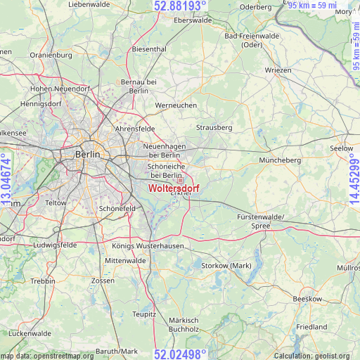
Woltersdorf GPS coordinates[2]
52° 27' 19.944" North, 13° 44' 59.496" East
| Map corner | latitude | longitude |
|---|---|---|
| Upper-left | 52.88193°, | 13.04674° |
| Center: | 52.45554°, | 13.74986° |
| Lower-right: | 52.02498°, | 14.45299° |
| Map W x H: | 95.3×95.3 km | = 59.2×59.2mi |
| max Lat: | 55.01917° ⇑23.1% North |
| Woltersdorf: | 52.45554° |
| min Lat: | ⇓76.9% South 47.40724° |
| min Long | Woltersdorf | max Long |
| 5.92978° | 13.74986° | 14.98853° |
| W 97.1%⇐ | ⇒2.9% E |
Elevation
Elevation of Woltersdorf is 51 m = 167 ft, and this is 198.1 m = 650 ft below average elevation for this country.
| Max E: |
1256 m = 4121 ft | 78.7% |
| Avg. | 249.1 m = 817 ft | |
| Woltersdorf | 51 m = 167 ft | |
Min E: |
-5 m = -16 ft | 21.3% |
See also: Germany elevation on elevation.city.
Geographical zone
Woltersdorf is located in North temperate zone (between Tropic of Cancer and the Arctic Circle). Distance of this North polar circle is 1568.7 km =974.7 mi to North.| Distance of | km | miles | from Woltersdorf |
|---|---|---|---|
| North Pole | 4174.6 | 2594 | to North |
| Arctic Circle | 1568.7 | 974.7 | to North |
| Tropic Cancer | 3226.6 | 2004.9 | to South |
| Equator | 5832.5 | 3624.1 | to South |


Nearby cities:
15 places around Woltersdorf: (largest is in red/bold)
• Altlandsberg
12.3 km =7.6 mi,  353°
353°
• Berlin Köpenick
11.4 km =7.1 mi,  262°
262°
• Erkner
4 km =2.5 mi,  175°
175°
• Friedrichshagen
8.5 km =5.3 mi,  266°
266°
• Grünau
12.3 km =7.6 mi,  249°
249°
• Grünheide
5.6 km =3.5 mi,  129°
129°
• Hoppegarten
8.8 km =5.5 mi,  320°
320°
• Köpenick
11.9 km =7.4 mi, 264°
• Mahlsdorf
11 km =6.8 mi,  302°
302°
• Müggelheim
7.6 km =4.7 mi,  229°
229°
• Neuenhagen
9.2 km =5.7 mi,  333°
333°
• Petershagen
7.7 km =4.8 mi,  19°
19°
• Rahnsdorf
4.5 km =2.8 mi, 249°
• Schmöckwitz
11.2 km =7 mi,  217°
217°
• Schöneiche
4.4 km =2.7 mi, 296°
Sources, notices
• [Note1] Compared only with cities in Germany existing in our database
• [Src1] Map data: © OpenStreetMap contributors (CC-BY-SA)
• [Src2] Other city data from geonames.org with taken over terms of usage.
• [Src3] Geographical zone / Annual Mean Temperature by Robert A. Rohde @ Wikipedia
