Friedrichshagen geodata
Friedrichshagen (Berlin) is a section of populated place; located in Germany in Europe/Berlin (GMT+2) time zone. With population of 17,529 people, there are 909 cities with bigger population in this country. Compared to other cities in Germany, 76.9% of cities are located further ↓South; 96.5% of cities are located further ←West and 83.7% of cities have higher elevation than Friedrichshagen. Note1


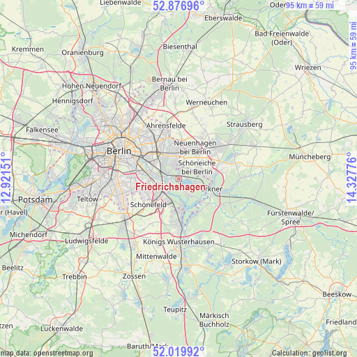
Friedrichshagen GPS coordinates[2]
52° 27' 1.872" North, 13° 37' 28.668" East
| Map corner | latitude | longitude |
|---|---|---|
| Upper-left | 52.87696°, | 12.92151° |
| Center: | 52.45052°, | 13.62463° |
| Lower-right: | 52.01992°, | 14.32776° |
| Map W x H: | 95.3×95.3 km | = 59.2×59.2mi |
| max Lat: | 55.01917° ⇑23.1% North |
| Friedrichshagen: | 52.45052° |
| min Lat: | ⇓76.9% South 47.40724° |
| min Long | Friedrichshagen | max Long |
| 5.92978° | 13.62463° | 14.98853° |
| W 96.5%⇐ | ⇒3.5% E |
Elevation
Elevation of Friedrichshagen is 38 m = 125 ft, and this is 211.1 m = 693 ft below average elevation for this country.
| Max E: |
1256 m = 4121 ft | 83.7% |
| Avg. | 249.1 m = 817 ft | |
| Friedrichshagen | 38 m = 125 ft | |
Min E: |
-5 m = -16 ft | 16.3% |
See also: Germany elevation on elevation.city.
Geographical zone
Friedrichshagen is located in North temperate zone (between Tropic of Cancer and the Arctic Circle). Distance of this North polar circle is 1569.2 km =975.1 mi to North.| Distance of | km | miles | from Friedrichshagen |
|---|---|---|---|
| North Pole | 4175.1 | 2594.3 | to North |
| Arctic Circle | 1569.2 | 975.1 | to North |
| Tropic Cancer | 3226 | 2004.5 | to South |
| Equator | 5832 | 3623.8 | to South |


Nearby cities:
15 places around Friedrichshagen: (largest is in red/bold)
• Adlershof
5.4 km =3.4 mi,  252°
252°
• Altglienicke
7.5 km =4.7 mi,  234°
234°
• Berlin Köpenick
3 km =1.9 mi, 252°
• Bohnsdorf
7.1 km =4.4 mi,  209°
209°
• Grünau
4.8 km =3 mi,  218°
218°
• Hoppegarten
7.9 km =4.9 mi,  21°
21°
• Karlshorst
7.3 km =4.5 mi,  300°
300°
• Kaulsdorf
7.8 km =4.8 mi,  341°
341°
• Köpenick
3.4 km =2.1 mi,  260°
260°
• Mahlsdorf
6.6 km =4.1 mi,  353°
353°
• Müggelheim
5.1 km =3.2 mi,  148°
148°
• Niederschöneweide
7.4 km =4.6 mi,  274°
274°
• Oberschöneweide
7.1 km =4.4 mi,  279°
279°
• Rahnsdorf
4.4 km =2.7 mi,  103°
103°
• Schöneiche
5.2 km =3.2 mi,  61°
61°
Sources, notices
• [Note1] Compared only with cities in Germany existing in our database
• [Src1] Map data: © OpenStreetMap contributors (CC-BY-SA)
• [Src2] Other city data from geonames.org with taken over terms of usage.
• [Src3] Geographical zone / Annual Mean Temperature by Robert A. Rohde @ Wikipedia
