Rahnsdorf geodata
Rahnsdorf (Berlin) is a section of populated place; located in Germany in Europe/Berlin (GMT+2) time zone. With population of 8,948 people, there are 1803 cities with bigger population in this country. Compared to other cities in Germany, 76.8% of cities are located further ↓South; 96.8% of cities are located further ←West and 84.5% of cities have higher elevation than Rahnsdorf. Note1


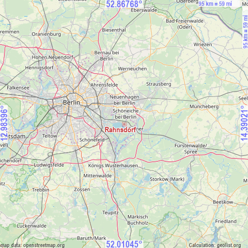
Rahnsdorf GPS coordinates[2]
52° 26' 28.14" North, 13° 41' 13.488" East
| Map corner | latitude | longitude |
|---|---|---|
| Upper-left | 52.86768°, | 12.98396° |
| Center: | 52.44115°, | 13.68708° |
| Lower-right: | 52.01045°, | 14.39021° |
| Map W x H: | 95.3×95.3 km | = 59.2×59.2mi |
| max Lat: | 55.01917° ⇑23.2% North |
| Rahnsdorf: | 52.44115° |
| min Lat: | ⇓76.8% South 47.40724° |
| min Long | Rahnsdorf | max Long |
| 5.92978° | 13.68708° | 14.98853° |
| W 96.8%⇐ | ⇒3.2% E |
Elevation
Elevation of Rahnsdorf is 36 m = 118 ft, and this is 213.1 m = 699 ft below average elevation for this country.
| Max E: |
1256 m = 4121 ft | 84.5% |
| Avg. | 249.1 m = 817 ft | |
| Rahnsdorf | 36 m = 118 ft | |
Min E: |
-5 m = -16 ft | 15.5% |
See also: Germany elevation on elevation.city.
Geographical zone
Rahnsdorf is located in North temperate zone (between Tropic of Cancer and the Arctic Circle). Distance of this North polar circle is 1570.3 km =975.7 mi to North.| Distance of | km | miles | from Rahnsdorf |
|---|---|---|---|
| North Pole | 4176.2 | 2595 | to North |
| Arctic Circle | 1570.3 | 975.7 | to North |
| Tropic Cancer | 3225 | 2003.9 | to South |
| Equator | 5830.9 | 3623.2 | to South |


Nearby cities:
15 places around Rahnsdorf: (largest is in red/bold)
• Adlershof
9.4 km =5.8 mi,  266°
266°
• Berlin Köpenick
7.1 km =4.4 mi, 271°
• Bohnsdorf
9.3 km =5.8 mi,  235°
235°
• Eichwalde
9.6 km =6 mi,  209°
209°
• Erkner
5.1 km =3.2 mi,  117°
117°
• Friedrichshagen
4.4 km =2.7 mi,  283°
283°
• Grünau
7.7 km =4.8 mi,  249°
249°
• Grünheide
8.8 km =5.5 mi,  102°
102°
• Hoppegarten
8.5 km =5.3 mi,  350°
350°
• Köpenick
7.6 km =4.7 mi, 273°
• Mahlsdorf
9.1 km =5.7 mi,  326°
326°
• Müggelheim
3.7 km =2.3 mi, 205°
• Schmöckwitz
7.8 km =4.8 mi,  199°
199°
• Schöneiche
3.5 km =2.2 mi,  5°
5°
• Woltersdorf
4.5 km =2.8 mi,  69°
69°
Sources, notices
• [Note1] Compared only with cities in Germany existing in our database
• [Src1] Map data: © OpenStreetMap contributors (CC-BY-SA)
• [Src2] Other city data from geonames.org with taken over terms of usage.
• [Src3] Geographical zone / Annual Mean Temperature by Robert A. Rohde @ Wikipedia
