Neuenhagen geodata
Neuenhagen (Brandenburg) is a populated place; located in Germany in Europe/Berlin (GMT+2) time zone. With population of 16,170 people, there are 986 cities with bigger population in this country. Compared to other cities in Germany, 77.8% of cities are located further ↓South; 96.8% of cities are located further ←West and 76.4% of cities have higher elevation than Neuenhagen. Note1
Administrative division(s):
- Level 1: Brandenburg
- Level 3: Landkreis Märkisch-Oderland
- Level 4: Neuenhagen bei Berlin


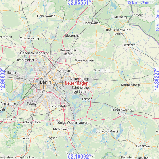
Neuenhagen GPS coordinates[2]
52° 31' 47.46" North, 13° 41' 20.904" East
| Map corner | latitude | longitude |
|---|---|---|
| Upper-left | 52.95551°, | 12.98602° |
| Center: | 52.52985°, | 13.68914° |
| Lower-right: | 52.10002°, | 14.39227° |
| Map W x H: | 95.1×95.1 km | = 59.1×59.1mi |
| max Lat: | 55.01917° ⇑22.2% North |
| Neuenhagen: | 52.52985° |
| min Lat: | ⇓77.8% South 47.40724° |
| min Long | Neuenhagen | max Long |
| 5.92978° | 13.68914° | 14.98853° |
| W 96.8%⇐ | ⇒3.2% E |
Elevation
Elevation of Neuenhagen is 58 m = 190 ft, and this is 191.1 m = 627 ft below average elevation for this country.
| Max E: |
1256 m = 4121 ft | 76.4% |
| Avg. | 249.1 m = 817 ft | |
| Neuenhagen | 58 m = 190 ft | |
Min E: |
-5 m = -16 ft | 23.6% |
See also: Germany elevation on elevation.city.
Geographical zone
Neuenhagen is located in North temperate zone (between Tropic of Cancer and the Arctic Circle). Distance of this North polar circle is 1560.4 km =969.6 mi to North.| Distance of | km | miles | from Neuenhagen |
|---|---|---|---|
| North Pole | 4166.3 | 2588.8 | to North |
| Arctic Circle | 1560.4 | 969.6 | to North |
| Tropic Cancer | 3234.9 | 2010.1 | to South |
| Equator | 5840.8 | 3629.3 | to South |


Nearby cities:
15 places around Neuenhagen: (largest is in red/bold)
• Ahrensfelde
9 km =5.6 mi,  305°
305°
• Altlandsberg
4.7 km =2.9 mi,  33°
33°
• Biesdorf
9.5 km =5.9 mi,  255°
255°
• Falkenberg
10.6 km =6.6 mi,  293°
293°
• Friedrichshagen
9.8 km =6.1 mi,  206°
206°
• Hellersdorf
5.4 km =3.4 mi,  273°
273°
• Hoppegarten
2.1 km =1.3 mi,  226°
226°
• Kaulsdorf
6.9 km =4.3 mi, 258°
• Mahlsdorf
5.6 km =3.5 mi,  245°
245°
• Marzahn
8.2 km =5.1 mi,  281°
281°
• Petershagen
6.7 km =4.2 mi,  98°
98°
• Rahnsdorf
9.9 km =6.2 mi,  180°
180°
• Schöneiche
6.3 km =3.9 mi, 178°
• Werneuchen
11.8 km =7.3 mi,  14°
14°
• Woltersdorf
9.2 km =5.7 mi,  153°
153°
Sources, notices
• [Note1] Compared only with cities in Germany existing in our database
• [Src1] Map data: © OpenStreetMap contributors (CC-BY-SA)
• [Src2] Other city data from geonames.org with taken over terms of usage.
• [Src3] Geographical zone / Annual Mean Temperature by Robert A. Rohde @ Wikipedia
