Wolfschlugen geodata
Wolfschlugen (Baden-Württemberg) is a seat of a fourth-order administrative division; located in Germany in Europe/Berlin (GMT+2) time zone. With population of 6,108 people, there are 2428 cities with bigger population in this country. Compared to other cities in Germany, 87.2% of cities are located further ↑North; 61% of cities are located further →East and 71.8% of cities have lower elevation than Wolfschlugen. Note1
Administrative division(s):
- Level 1: Baden-Württemberg
- Level 2: Regierungsbezirk Stuttgart
- Level 3: Landkreis Esslingen
- Level 4: Wolfschlugen


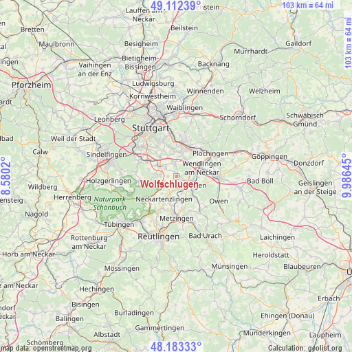
Wolfschlugen GPS coordinates[2]
48° 39' 0" North, 9° 16' 59.988" East
| Map corner | latitude | longitude |
|---|---|---|
| Upper-left | 49.11239°, | 8.5802° |
| Center: | 48.65°, | 9.28333° |
| Lower-right: | 48.18333°, | 9.98645° |
| Map W x H: | 103.3×103.3 km | = 64.2×64.2mi |
| max Lat: | 55.01917° ⇑87.2% North |
| Wolfschlugen: | 48.65° |
| min Lat: | ⇓12.8% South 47.40724° |
| min Long | Wolfschlugen | max Long |
| 5.92978° | 9.28333° | 14.98853° |
| W 39%⇐ | ⇒61% E |
Elevation
Elevation of Wolfschlugen is 373 m = 1224 ft, and this is 123.9 m = 406 ft above average elevation for this country.
| Max E: |
1256 m = 4121 ft | 28.2% |
| Wolfschlugen | 373 m 1224 ft | |
| Avg. | 249.1 m = 817 ft | |
Min E: |
-5 m = -16 ft | 71.8% |
See also: Germany elevation on elevation.city.
Geographical zone
Wolfschlugen is located in North temperate zone (between Tropic of Cancer and the Arctic Circle). Distance of this North polar circle is 1991.8 km =1237.6 mi to North.| Distance of | km | miles | from Wolfschlugen |
|---|---|---|---|
| North Pole | 4597.7 | 2856.9 | to North |
| Arctic Circle | 1991.8 | 1237.6 | to North |
| Tropic Cancer | 2803.5 | 1742 | to South |
| Equator | 5409.4 | 3361.2 | to South |


Nearby cities:
15 places around Wolfschlugen: (largest is in red/bold)
• Altdorf
6.3 km =3.9 mi,  187°
187°
• Altenriet
7.9 km =4.9 mi,  214°
214°
• Denkendorf
5.6 km =3.5 mi,  25°
25°
• Filderstadt
4.7 km =2.9 mi,  279°
279°
• Frickenhausen
8.4 km =5.2 mi,  138°
138°
• Großbettlingen
6.9 km =4.3 mi,  164°
164°
• Köngen
7.2 km =4.5 mi,  58°
58°
• Neckartailfingen
4.5 km =2.8 mi,  198°
198°
• Neckartenzlingen
7.6 km =4.7 mi, 208°
• Neuhausen auf den Fildern
3.7 km =2.3 mi,  0°
0°
• Nürtingen
5.1 km =3.2 mi,  122°
122°
• Oberboihingen
6.1 km =3.8 mi,  90°
90°
• Schlaitdorf
6.8 km =4.2 mi,  221°
221°
• Unterensingen
5.5 km =3.4 mi,  84°
84°
• Wendlingen am Neckar
7.2 km =4.5 mi,  70°
70°
Sources, notices
• [Note1] Compared only with cities in Germany existing in our database
• [Src1] Map data: © OpenStreetMap contributors (CC-BY-SA)
• [Src2] Other city data from geonames.org with taken over terms of usage.
• [Src3] Geographical zone / Annual Mean Temperature by Robert A. Rohde @ Wikipedia
