Filderstadt geodata
Filderstadt (Baden-Württemberg) is a seat of a fourth-order administrative division; located in Germany in Europe/Berlin (GMT+2) time zone. With population of 43,550 people, there are 280 cities with bigger population in this country. Compared to other cities in Germany, 87% of cities are located further ↑North; 62% of cities are located further →East and 74.4% of cities have lower elevation than Filderstadt. Note1
Administrative division(s):
- Level 1: Baden-Württemberg
- Level 2: Regierungsbezirk Stuttgart
- Level 3: Landkreis Esslingen
- Level 4: Filderstadt


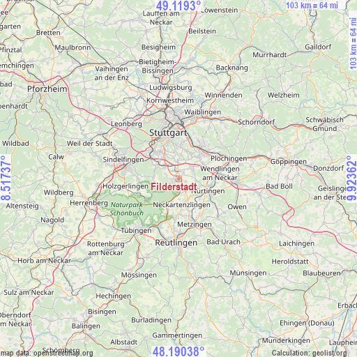
Filderstadt GPS coordinates[2]
48° 39' 25.128" North, 9° 13' 13.764" East
| Map corner | latitude | longitude |
|---|---|---|
| Upper-left | 49.1193°, | 8.51737° |
| Center: | 48.65698°, | 9.22049° |
| Lower-right: | 48.19038°, | 9.92362° |
| Map W x H: | 103.3×103.3 km | = 64.2×64.2mi |
| max Lat: | 55.01917° ⇑87% North |
| Filderstadt: | 48.65698° |
| min Lat: | ⇓13% South 47.40724° |
| min Long | Filderstadt | max Long |
| 5.92978° | 9.22049° | 14.98853° |
| W 38%⇐ | ⇒62% E |
Elevation
Elevation of Filderstadt is 393 m = 1289 ft, and this is 143.9 m = 472 ft above average elevation for this country.
| Max E: |
1256 m = 4121 ft | 25.6% |
| Filderstadt | 393 m 1289 ft | |
| Avg. | 249.1 m = 817 ft | |
Min E: |
-5 m = -16 ft | 74.4% |
See also: Filderstadt elevation on elevation.city.
Geographical zone
Filderstadt is located in North temperate zone (between Tropic of Cancer and the Arctic Circle). Distance of this North polar circle is 1991 km =1237.1 mi to North.| Distance of | km | miles | from Filderstadt |
|---|---|---|---|
| North Pole | 4596.9 | 2856.4 | to North |
| Arctic Circle | 1991 | 1237.1 | to North |
| Tropic Cancer | 2804.2 | 1742.4 | to South |
| Equator | 5410.1 | 3361.7 | to South |


Nearby cities:
15 places around Filderstadt: (largest is in red/bold)
• Altdorf
7.9 km =4.9 mi,  151°
151°
• Altenriet
7.3 km =4.5 mi,  179°
179°
• Denkendorf
8.3 km =5.2 mi,  58°
58°
• Großbettlingen
9.8 km =6.1 mi,  139°
139°
• Leinfelden-Echterdingen
5.6 km =3.5 mi,  316°
316°
• Neckartailfingen
6 km =3.7 mi, 147°
• Neckartenzlingen
7.5 km =4.7 mi,  171°
171°
• Neuhausen auf den Fildern
5.5 km =3.4 mi, 57°
• Nürtingen
9.6 km =6 mi,  111°
111°
• Ostfildern
8.1 km =5 mi,  15°
15°
• Schlaitdorf
5.9 km =3.7 mi, 178°
• Steinenbronn
7.7 km =4.8 mi,  278°
278°
• Unterensingen
10.1 km =6.3 mi,  91°
91°
• Waldenbuch
6.8 km =4.2 mi,  252°
252°
• Wolfschlugen
4.7 km =2.9 mi,  99°
99°
Sources, notices
• [Note1] Compared only with cities in Germany existing in our database
• [Src1] Map data: © OpenStreetMap contributors (CC-BY-SA)
• [Src2] Other city data from geonames.org with taken over terms of usage.
• [Src3] Geographical zone / Annual Mean Temperature by Robert A. Rohde @ Wikipedia
