Wolframs-Eschenbach geodata
Wolframs-Eschenbach (Bavaria) is a populated place; located in Germany in Europe/Berlin (GMT+2) time zone. With population of 2,911 people, there are 4080 cities with bigger population in this country. Compared to other cities in Germany, 80% of cities are located further ↑North; 62.9% of cities are located further ←West and 80.8% of cities have lower elevation than Wolframs-Eschenbach. Note1
Administrative division(s):
- Level 1: Bavaria
- Level 2: Regierungsbezirk Mittelfranken
- Level 3: Landkreis Ansbach
- Level 4: Wolframs-Eschenbach


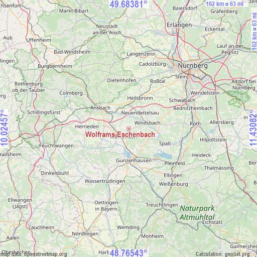
Wolframs-Eschenbach GPS coordinates[2]
49° 13' 36.3" North, 10° 43' 39.684" East
| Map corner | latitude | longitude |
|---|---|---|
| Upper-left | 49.68381°, | 10.02457° |
| Center: | 49.22675°, | 10.72769° |
| Lower-right: | 48.76543°, | 11.43082° |
| Map W x H: | 102.1×102.1 km | = 63.4×63.4mi |
| max Lat: | 55.01917° ⇑80% North |
| Wolframs-Eschenbach: | 49.22675° |
| min Lat: | ⇓20% South 47.40724° |
| min Long | Wolframs-Eschen | max Long |
| 5.92978° | 10.72769° | 14.98853° |
| W 62.9%⇐ | ⇒37.1% E |
Elevation
Elevation of Wolframs-Eschenbach is 438 m = 1437 ft, and this is 188.9 m = 620 ft above average elevation for this country.
| Max E: |
1256 m = 4121 ft | 19.2% |
| Wolframs-Eschenbach | 438 m 1437 ft | |
| Avg. | 249.1 m = 817 ft | |
Min E: |
-5 m = -16 ft | 80.8% |
See also: Germany elevation on elevation.city.
Geographical zone
Wolframs-Eschenbach is located in North temperate zone (between Tropic of Cancer and the Arctic Circle). Distance of this North polar circle is 1927.7 km =1197.8 mi to North.| Distance of | km | miles | from Wolframs-Eschenbach |
|---|---|---|---|
| North Pole | 4533.6 | 2817 | to North |
| Arctic Circle | 1927.7 | 1197.8 | to North |
| Tropic Cancer | 2867.6 | 1781.8 | to South |
| Equator | 5473.5 | 3401.1 | to South |


Nearby cities:
15 places around Wolframs-Eschenbach: (largest is in red/bold)
• Ansbach
13.1 km =8.1 mi,  311°
311°
• Arberg
12.2 km =7.6 mi,  221°
221°
• Burgoberbach
10.5 km =6.5 mi,  273°
273°
• Gunzenhausen
12.5 km =7.8 mi,  169°
169°
• Haundorf
6.5 km =4 mi,  150°
150°
• Heilsbronn
12.9 km =8 mi,  19°
19°
• Merkendorf
3.1 km =1.9 mi,  213°
213°
• Mitteleschenbach
5.4 km =3.4 mi,  108°
108°
• Muhr am See
8.1 km =5 mi,  184°
184°
• Neuendettelsau
7.5 km =4.7 mi,  32°
32°
• Ornbau
7.6 km =4.7 mi, 222°
• Petersaurach
8.3 km =5.2 mi,  11°
11°
• Sachsen
8.6 km =5.3 mi,  324°
324°
• Weidenbach
6.8 km =4.2 mi,  242°
242°
• Windsbach
7.5 km =4.7 mi,  71°
71°
Sources, notices
• [Note1] Compared only with cities in Germany existing in our database
• [Src1] Map data: © OpenStreetMap contributors (CC-BY-SA)
• [Src2] Other city data from geonames.org with taken over terms of usage.
• [Src3] Geographical zone / Annual Mean Temperature by Robert A. Rohde @ Wikipedia
