Barnekow geodata
Barnekow (Mecklenburg-Vorpommern) is a populated place; located in Germany in Europe/Berlin (GMT+2) time zone. With population of 680 people, there are 8420 cities with bigger population in this country. Compared to other cities in Germany, 90.7% of cities are located further ↓South; 72.4% of cities are located further ←West and 82.8% of cities have higher elevation than Barnekow. Note1
Administrative division(s):
- Level 1: Mecklenburg-Vorpommern
- Level 3: Nordwestmecklenburg
- Level 4: Barnekow


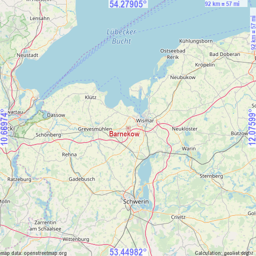
Barnekow GPS coordinates[2]
53° 51' 59.364" North, 11° 22' 22.296" East
| Map corner | latitude | longitude |
|---|---|---|
| Upper-left | 54.27905°, | 10.66974° |
| Center: | 53.86649°, | 11.37286° |
| Lower-right: | 53.44982°, | 12.07599° |
| Map W x H: | 92.2×92.2 km | = 57.3×57.3mi |
| max Lat: | 55.01917° ⇑9.3% North |
| Barnekow: | 53.86649° |
| min Lat: | ⇓90.7% South 47.40724° |
| min Long | Barnekow | max Long |
| 5.92978° | 11.37286° | 14.98853° |
| W 72.4%⇐ | ⇒27.6% E |
Elevation
Elevation of Barnekow is 40 m = 131 ft, and this is 209.1 m = 686 ft below average elevation for this country.
| Max E: |
1256 m = 4121 ft | 82.8% |
| Avg. | 249.1 m = 817 ft | |
| Barnekow | 40 m = 131 ft | |
Min E: |
-5 m = -16 ft | 17.2% |
See also: Germany elevation on elevation.city.
Geographical zone
Barnekow is located in North temperate zone (between Tropic of Cancer and the Arctic Circle). Distance of this North polar circle is 1411.8 km =877.3 mi to North.| Distance of | km | miles | from Barnekow |
|---|---|---|---|
| North Pole | 4017.7 | 2496.5 | to North |
| Arctic Circle | 1411.8 | 877.3 | to North |
| Tropic Cancer | 3383.5 | 2102.4 | to South |
| Equator | 5989.4 | 3721.6 | to South |


Nearby cities:
15 places around Barnekow: (largest is in red/bold)
• Beidendorf
4.4 km =2.7 mi,  166°
166°
• Bobitz
7 km =4.3 mi,  187°
187°
• Gramkow
7.1 km =4.4 mi,  329°
329°
• Grevesmühlen
11.9 km =7.4 mi,  268°
268°
• Groß Krankow
6.2 km =3.9 mi,  203°
203°
• Groß Stieten
7.8 km =4.8 mi,  139°
139°
• Hornstorf
11.5 km =7.1 mi,  65°
65°
• Lübow
10.1 km =6.3 mi,  98°
98°
• Mecklenburg
6.5 km =4 mi,  114°
114°
• Plüschow
7.6 km =4.7 mi,  243°
243°
• Testorf-Steinfort
12.1 km =7.5 mi,  214°
214°
• Upahl
11.5 km =7.1 mi, 243°
• Weitendorf
3.5 km =2.2 mi,  339°
339°
• Wismar
6 km =3.7 mi,  60°
60°
• Zierow
6.6 km =4.1 mi,  1°
1°
Sources, notices
• [Note1] Compared only with cities in Germany existing in our database
• [Src1] Map data: © OpenStreetMap contributors (CC-BY-SA)
• [Src2] Other city data from geonames.org with taken over terms of usage.
• [Src3] Geographical zone / Annual Mean Temperature by Robert A. Rohde @ Wikipedia
