Groß Krankow geodata
Groß Krankow (Mecklenburg-Vorpommern) is a populated place; located in Germany in Europe/Berlin (GMT+2) time zone. With population of 737 people, there are 8162 cities with bigger population in this country. Compared to other cities in Germany, 90.2% of cities are located further ↓South; 71.8% of cities are located further ←West and 77.3% of cities have higher elevation than Groß Krankow. Note1
Administrative division(s):
- Level 1: Mecklenburg-Vorpommern
- Level 3: Nordwestmecklenburg
- Level 4: Bobitz


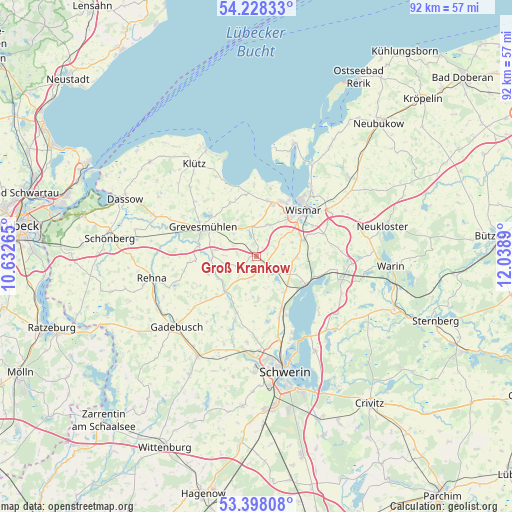
Groß Krankow GPS coordinates[2]
53° 48' 54.936" North, 11° 20' 8.772" East
| Map corner | latitude | longitude |
|---|---|---|
| Upper-left | 54.22833°, | 10.63265° |
| Center: | 53.81526°, | 11.33577° |
| Lower-right: | 53.39808°, | 12.0389° |
| Map W x H: | 92.3×92.3 km | = 57.4×57.4mi |
| max Lat: | 55.01917° ⇑9.8% North |
| Groß Krankow: | 53.81526° |
| min Lat: | ⇓90.2% South 47.40724° |
| min Long | Groß Krankow | max Long |
| 5.92978° | 11.33577° | 14.98853° |
| W 71.8%⇐ | ⇒28.2% E |
Elevation
Elevation of Groß Krankow is 55 m = 180 ft, and this is 194.1 m = 637 ft below average elevation for this country.
| Max E: |
1256 m = 4121 ft | 77.3% |
| Avg. | 249.1 m = 817 ft | |
| Groß Krankow | 55 m = 180 ft | |
Min E: |
-5 m = -16 ft | 22.7% |
See also: Germany elevation on elevation.city.
Geographical zone
Groß Krankow is located in North temperate zone (between Tropic of Cancer and the Arctic Circle). Distance of this North polar circle is 1417.5 km =880.8 mi to North.| Distance of | km | miles | from Groß Krankow |
|---|---|---|---|
| North Pole | 4023.4 | 2500 | to North |
| Arctic Circle | 1417.5 | 880.8 | to North |
| Tropic Cancer | 3377.8 | 2098.9 | to South |
| Equator | 5983.7 | 3718.1 | to South |


Nearby cities:
15 places around Groß Krankow: (largest is in red/bold)
• Alt Meteln
7.6 km =4.7 mi,  177°
177°
• Bad Kleinen
10.2 km =6.3 mi,  118°
118°
• Barnekow
6.2 km =3.9 mi,  23°
23°
• Beidendorf
3.7 km =2.3 mi,  67°
67°
• Bobitz
1.9 km =1.2 mi,  127°
127°
• Grevesmühlen
10.9 km =6.8 mi,  299°
299°
• Groß Stieten
7.5 km =4.7 mi,  91°
91°
• Mecklenburg
8.9 km =5.5 mi, 69°
• Mühlen Eichsen
8.5 km =5.3 mi,  221°
221°
• Plüschow
5 km =3.1 mi, 297°
• Rüting
7.9 km =4.9 mi,  252°
252°
• Testorf-Steinfort
6.1 km =3.8 mi,  225°
225°
• Upahl
7.9 km =4.9 mi,  274°
274°
• Weitendorf
9 km =5.6 mi,  7°
7°
• Zickhusen
8.1 km =5 mi,  140°
140°
Sources, notices
• [Note1] Compared only with cities in Germany existing in our database
• [Src1] Map data: © OpenStreetMap contributors (CC-BY-SA)
• [Src2] Other city data from geonames.org with taken over terms of usage.
• [Src3] Geographical zone / Annual Mean Temperature by Robert A. Rohde @ Wikipedia
