Oberndorf geodata
Oberndorf (Lower Saxony) is a seat of a fourth-order administrative division; located in Germany in Europe/Berlin (GMT+2) time zone. With population of 1,556 people, there are 5772 cities with bigger population in this country. Compared to other cities in Germany, 89.3% of cities are located further ↓South; 63.3% of cities are located further →East and 99.1% of cities have higher elevation than Oberndorf. Note1


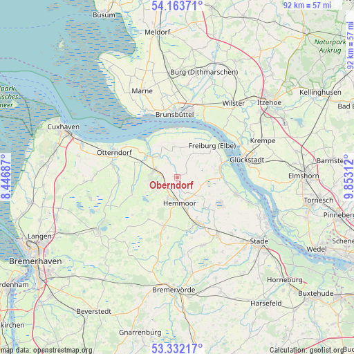
Oberndorf GPS coordinates[2]
53° 45' 0" North, 9° 9' 0" East
| Map corner | latitude | longitude |
|---|---|---|
| Upper-left | 54.16371°, | 8.44687° |
| Center: | 53.75°, | 9.15° |
| Lower-right: | 53.33217°, | 9.85312° |
| Map W x H: | 92.5×92.5 km | = 57.5×57.5mi |
| max Lat: | 55.01917° ⇑10.7% North |
| Oberndorf: | 53.75° |
| min Lat: | ⇓89.3% South 47.40724° |
| min Long | Oberndorf | max Long |
| 5.92978° | 9.15° | 14.98853° |
| W 36.7%⇐ | ⇒63.3% E |
Elevation
Elevation of Oberndorf is 0 m = 0 ft, and this is 249.1 m = 817 ft below average elevation for this country.
| Max E: |
1256 m = 4121 ft | 99.1% |
| Avg. | 249.1 m = 817 ft | |
| Oberndorf | 0 m = 0 ft | |
Min E: |
-5 m = -16 ft | 0.9% |
See also: Germany elevation on elevation.city.
Geographical zone
Oberndorf is located in North temperate zone (between Tropic of Cancer and the Arctic Circle). Distance of this North polar circle is 1424.7 km =885.3 mi to North.| Distance of | km | miles | from Oberndorf |
|---|---|---|---|
| North Pole | 4030.6 | 2504.5 | to North |
| Arctic Circle | 1424.7 | 885.3 | to North |
| Tropic Cancer | 3370.5 | 2094.3 | to South |
| Equator | 5976.4 | 3713.6 | to South |


Nearby cities:
15 places around Oberndorf: (largest is in red/bold)
• Balje
9.3 km =5.8 mi,  353°
353°
• Belum
12.3 km =7.6 mi,  306°
306°
• Bülkau
11.3 km =7 mi,  267°
267°
• Cadenberge
6.1 km =3.8 mi,  290°
290°
• Freiburg
12.3 km =7.6 mi,  47°
47°
• Geversdorf
7.1 km =4.4 mi,  321°
321°
• Großenwörden
10.7 km =6.6 mi,  133°
133°
• Hemmoor
7 km =4.3 mi,  177°
177°
• Krummendeich
9.7 km =6 mi,  21°
21°
• Lamstedt
13.4 km =8.3 mi,  194°
194°
• Neuhaus an der Oste
9.5 km =5.9 mi, 306°
• Oederquart
8.2 km =5.1 mi,  44°
44°
• Osten
6.5 km =4 mi,  149°
149°
• Wingst
4.8 km =3 mi,  250°
250°
• Wischhafen
11.6 km =7.2 mi,  71°
71°
Sources, notices
• [Note1] Compared only with cities in Germany existing in our database
• [Src1] Map data: © OpenStreetMap contributors (CC-BY-SA)
• [Src2] Other city data from geonames.org with taken over terms of usage.
• [Src3] Geographical zone / Annual Mean Temperature by Robert A. Rohde @ Wikipedia
