Windberg geodata
Windberg (Bavaria) is a seat of a fourth-order administrative division; located in Germany in Europe/Berlin (GMT+2) time zone. With population of 1,059 people, there are 6968 cities with bigger population in this country. Compared to other cities in Germany, 83.6% of cities are located further ↑North; 90.2% of cities are located further ←West and 79.5% of cities have lower elevation than Windberg. Note1
Administrative division(s):
- Level 1: Bavaria
- Level 2: Lower Bavaria
- Level 3: Landkreis Straubing-Bogen
- Level 4: Windberg


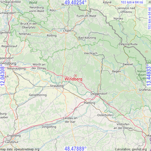
Windberg GPS coordinates[2]
48° 56' 34.26" North, 12° 44' 46.32" East
| Map corner | latitude | longitude |
|---|---|---|
| Upper-left | 49.40254°, | 12.04308° |
| Center: | 48.94285°, | 12.7462° |
| Lower-right: | 48.47889°, | 13.44933° |
| Map W x H: | 102.7×102.7 km | = 63.8×63.8mi |
| max Lat: | 55.01917° ⇑83.6% North |
| Windberg: | 48.94285° |
| min Lat: | ⇓16.4% South 47.40724° |
| min Long | Windberg | max Long |
| 5.92978° | 12.7462° | 14.98853° |
| W 90.2%⇐ | ⇒9.8% E |
Elevation
Elevation of Windberg is 430 m = 1411 ft, and this is 180.9 m = 594 ft above average elevation for this country.
| Max E: |
1256 m = 4121 ft | 20.5% |
| Windberg | 430 m 1411 ft | |
| Avg. | 249.1 m = 817 ft | |
Min E: |
-5 m = -16 ft | 79.5% |
See also: Germany elevation on elevation.city.
Geographical zone
Windberg is located in North temperate zone (between Tropic of Cancer and the Arctic Circle). Distance of this North polar circle is 1959.2 km =1217.4 mi to North.| Distance of | km | miles | from Windberg |
|---|---|---|---|
| North Pole | 4565.1 | 2836.6 | to North |
| Arctic Circle | 1959.2 | 1217.4 | to North |
| Tropic Cancer | 2836 | 1762.2 | to South |
| Equator | 5441.9 | 3381.4 | to South |


Nearby cities:
15 places around Windberg: (largest is in red/bold)
• Ascha
10.4 km =6.5 mi,  307°
307°
• Bernried
10.4 km =6.5 mi,  106°
106°
• Bogen
5.4 km =3.4 mi,  229°
229°
• Böbrach
10.1 km =6.3 mi,  96°
96°
• Haibach
9.3 km =5.8 mi,  346°
346°
• Haselbach
7.8 km =4.8 mi,  329°
329°
• Hunderdorf
1.2 km =0.7 mi, 310°
• Hunderdorf
7.8 km =4.8 mi,  222°
222°
• Mitterfels
6.2 km =3.9 mi, 306°
• Neukirchen
3.6 km =2.2 mi,  10°
10°
• Niederwinkling
7.7 km =4.8 mi,  149°
149°
• Perasdorf
4 km =2.5 mi,  78°
78°
• Sankt Englmar
8.9 km =5.5 mi,  41°
41°
• Schwarzach
5.6 km =3.5 mi,  122°
122°
• Steinach
10.2 km =6.3 mi,  277°
277°
Sources, notices
• [Note1] Compared only with cities in Germany existing in our database
• [Src1] Map data: © OpenStreetMap contributors (CC-BY-SA)
• [Src2] Other city data from geonames.org with taken over terms of usage.
• [Src3] Geographical zone / Annual Mean Temperature by Robert A. Rohde @ Wikipedia
