Hunderdorf geodata
Hunderdorf (Bavaria) is a populated locality; located in Germany in Europe/Berlin (GMT+2) time zone. With population of 3,352 people, there are 3720 cities with bigger population in this country. Compared to other cities in Germany, 84.2% of cities are located further ↑North; 89.6% of cities are located further ←West and 64.5% of cities have lower elevation than Hunderdorf. Note1
Administrative division(s):
- Level 1: Bavaria
- Level 2: Lower Bavaria
- Level 3: Landkreis Straubing-Bogen
- Level 4: Aiterhofen


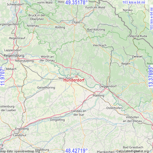
Hunderdorf GPS coordinates[2]
48° 53' 29.832" North, 12° 40' 25.752" East
| Map corner | latitude | longitude |
|---|---|---|
| Upper-left | 49.35178°, | 11.9707° |
| Center: | 48.89162°, | 12.67382° |
| Lower-right: | 48.42719°, | 13.37695° |
| Map W x H: | 102.8×102.8 km | = 63.9×63.9mi |
| max Lat: | 55.01917° ⇑84.2% North |
| Hunderdorf: | 48.89162° |
| min Lat: | ⇓15.8% South 47.40724° |
| min Long | Hunderdorf | max Long |
| 5.92978° | 12.67382° | 14.98853° |
| W 89.6%⇐ | ⇒10.4% E |
Elevation
Elevation of Hunderdorf is 318 m = 1043 ft, and this is 68.9 m = 226 ft above average elevation for this country.
| Max E: |
1256 m = 4121 ft | 35.5% |
| Hunderdorf | 318 m 1043 ft | |
| Avg. | 249.1 m = 817 ft | |
Min E: |
-5 m = -16 ft | 64.5% |
See also: Germany elevation on elevation.city.
Geographical zone
Hunderdorf is located in North temperate zone (between Tropic of Cancer and the Arctic Circle). Distance of this North polar circle is 1964.9 km =1220.9 mi to North.| Distance of | km | miles | from Hunderdorf |
|---|---|---|---|
| North Pole | 4570.8 | 2840.2 | to North |
| Arctic Circle | 1964.9 | 1220.9 | to North |
| Tropic Cancer | 2830.3 | 1758.7 | to South |
| Equator | 5436.2 | 3377.9 | to South |


Nearby cities:
15 places around Hunderdorf: (largest is in red/bold)
• Alterhofen
6.4 km =4 mi,  218°
218°
• Bogen
2.5 km =1.6 mi,  27°
27°
• Hunderdorf
7.8 km =4.8 mi, 33°
• Irlbach
8 km =5 mi,  134°
134°
• Kirchroth
11.1 km =6.9 mi,  305°
305°
• Mitterfels
9.4 km =5.8 mi,  2°
2°
• Neukirchen
11 km =6.8 mi, 32°
• Niederwinkling
9.3 km =5.8 mi,  95°
95°
• Oberschneiding
10.9 km =6.8 mi,  192°
192°
• Parkstetten
6.1 km =3.8 mi,  297°
297°
• Schwarzach
10.4 km =6.5 mi,  75°
75°
• Steinach
8.5 km =5.3 mi,  324°
324°
• Straubing
7.4 km =4.6 mi,  261°
261°
• Straßkirchen
7.6 km =4.7 mi,  152°
152°
• Windberg
7.8 km =4.8 mi,  42°
42°
Sources, notices
• [Note1] Compared only with cities in Germany existing in our database
• [Src1] Map data: © OpenStreetMap contributors (CC-BY-SA)
• [Src2] Other city data from geonames.org with taken over terms of usage.
• [Src3] Geographical zone / Annual Mean Temperature by Robert A. Rohde @ Wikipedia
