Wilhelmsdorf geodata
Wilhelmsdorf (Baden-Württemberg) is a seat of a fourth-order administrative division; located in Germany in Europe/Berlin (GMT+2) time zone. With population of 4,903 people, there are 2858 cities with bigger population in this country. Compared to other cities in Germany, 97% of cities are located further ↑North; 58.9% of cities are located further →East and 95.7% of cities have lower elevation than Wilhelmsdorf. Note1
Administrative division(s):
- Level 1: Baden-Württemberg
- Level 2: Tübingen Region
- Level 3: Landkreis Ravensburg
- Level 4: Wilhelmsdorf


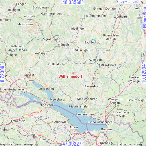
Wilhelmsdorf GPS coordinates[2]
47° 51' 58.032" North, 9° 25' 34.356" East
| Map corner | latitude | longitude |
|---|---|---|
| Upper-left | 48.33568°, | 8.72309° |
| Center: | 47.86612°, | 9.42621° |
| Lower-right: | 47.39227°, | 10.12934° |
| Map W x H: | 104.9×104.9 km | = 65.2×65.2mi |
| max Lat: | 55.01917° ⇑97% North |
| Wilhelmsdorf: | 47.86612° |
| min Lat: | ⇓3% South 47.40724° |
| min Long | Wilhelmsdorf | max Long |
| 5.92978° | 9.42621° | 14.98853° |
| W 41.1%⇐ | ⇒58.9% E |
Elevation
Elevation of Wilhelmsdorf is 616 m = 2021 ft, and this is 366.9 m = 1204 ft above average elevation for this country.
| Max E: |
1256 m = 4121 ft | 4.3% |
| Wilhelmsdorf | 616 m 2021 ft | |
| Avg. | 249.1 m = 817 ft | |
Min E: |
-5 m = -16 ft | 95.7% |
See also: Germany elevation on elevation.city.
Geographical zone
Wilhelmsdorf is located in North temperate zone (between Tropic of Cancer and the Arctic Circle). Distance of this North polar circle is 2079 km =1291.8 mi to North.| Distance of | km | miles | from Wilhelmsdorf |
|---|---|---|---|
| North Pole | 4684.8 | 2911 | to North |
| Arctic Circle | 2079 | 1291.8 | to North |
| Tropic Cancer | 2716.3 | 1687.8 | to South |
| Equator | 5322.2 | 3307.1 | to South |


Nearby cities:
15 places around Wilhelmsdorf: (largest is in red/bold)
• Altshausen
10.9 km =6.8 mi,  46°
46°
• Ebenweiler
7.7 km =4.8 mi,  60°
60°
• Eichstegen
9.3 km =5.8 mi,  36°
36°
• Fleischwangen
4.7 km =2.9 mi,  65°
65°
• Frickingen
12.8 km =8 mi,  243°
243°
• Fronreute
10.7 km =6.6 mi,  87°
87°
• Guggenhausen
4.2 km =2.6 mi,  25°
25°
• Heiligenberg
9.8 km =6.1 mi, 239°
• Horgenzell
8.6 km =5.3 mi,  141°
141°
• Hoßkirch
9.5 km =5.9 mi,  10°
10°
• Illmensee
4 km =2.5 mi,  263°
263°
• Königseggwald
7.5 km =4.7 mi,  354°
354°
• Ostrach
9.9 km =6.2 mi,  341°
341°
• Riedhausen
4.8 km =3 mi,  2°
2°
• Unterwaldhausen
4.8 km =3 mi, 38°
Sources, notices
• [Note1] Compared only with cities in Germany existing in our database
• [Src1] Map data: © OpenStreetMap contributors (CC-BY-SA)
• [Src2] Other city data from geonames.org with taken over terms of usage.
• [Src3] Geographical zone / Annual Mean Temperature by Robert A. Rohde @ Wikipedia
