Wiesensteig geodata
Wiesensteig (Baden-Württemberg) is a populated place; located in Germany in Europe/Berlin (GMT+2) time zone. With population of 2,199 people, there are 4805 cities with bigger population in this country. Compared to other cities in Germany, 88.3% of cities are located further ↑North; 55.7% of cities are located further →East and 94.6% of cities have lower elevation than Wiesensteig. Note1
Administrative division(s):
- Level 1: Baden-Württemberg
- Level 2: Regierungsbezirk Stuttgart
- Level 3: Landkreis Göppingen
- Level 4: Wiesensteig


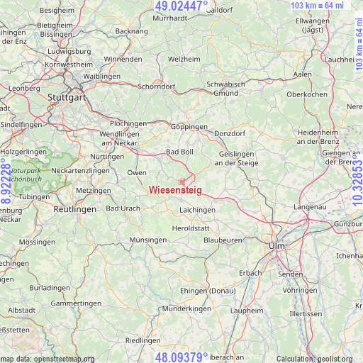
Wiesensteig GPS coordinates[2]
48° 33' 40.572" North, 9° 37' 31.44" East
| Map corner | latitude | longitude |
|---|---|---|
| Upper-left | 49.02447°, | 8.92228° |
| Center: | 48.56127°, | 9.6254° |
| Lower-right: | 48.09379°, | 10.32853° |
| Map W x H: | 103.5×103.5 km | = 64.3×64.3mi |
| max Lat: | 55.01917° ⇑88.3% North |
| Wiesensteig: | 48.56127° |
| min Lat: | ⇓11.7% South 47.40724° |
| min Long | Wiesensteig | max Long |
| 5.92978° | 9.6254° | 14.98853° |
| W 44.3%⇐ | ⇒55.7% E |
Elevation
Elevation of Wiesensteig is 590 m = 1936 ft, and this is 340.9 m = 1118 ft above average elevation for this country.
| Max E: |
1256 m = 4121 ft | 5.4% |
| Wiesensteig | 590 m 1936 ft | |
| Avg. | 249.1 m = 817 ft | |
Min E: |
-5 m = -16 ft | 94.6% |
See also: Germany elevation on elevation.city.
Geographical zone
Wiesensteig is located in North temperate zone (between Tropic of Cancer and the Arctic Circle). Distance of this North polar circle is 2001.7 km =1243.8 mi to North.| Distance of | km | miles | from Wiesensteig |
|---|---|---|---|
| North Pole | 4607.6 | 2863 | to North |
| Arctic Circle | 2001.7 | 1243.8 | to North |
| Tropic Cancer | 2793.6 | 1735.9 | to South |
| Equator | 5399.5 | 3355.1 | to South |


Nearby cities:
15 places around Wiesensteig: (largest is in red/bold)
• Aichelberg
9.4 km =5.8 mi,  331°
331°
• Bad Ditzenbach
6.5 km =4 mi,  62°
62°
• Boll
9.2 km =5.7 mi,  354°
354°
• Deggingen
7.9 km =4.9 mi, 59°
• Dürnau
8.9 km =5.5 mi,  4°
4°
• Eschenbach
10.7 km =6.6 mi,  18°
18°
• Gammelshausen
9 km =5.6 mi,  11°
11°
• Gruibingen
4 km =2.5 mi, 20°
• Hohenstadt
3.4 km =2.1 mi,  123°
123°
• Laichingen
9.2 km =5.7 mi,  150°
150°
• Mühlhausen
2.9 km =1.8 mi,  54°
54°
• Neidlingen
4.9 km =3 mi,  293°
293°
• Weilheim an der Teck
8.9 km =5.5 mi,  313°
313°
• Westerheim
5.1 km =3.2 mi,  180°
180°
• Zell unter Aichelberg
10.5 km =6.5 mi,  337°
337°
Sources, notices
• [Note1] Compared only with cities in Germany existing in our database
• [Src1] Map data: © OpenStreetMap contributors (CC-BY-SA)
• [Src2] Other city data from geonames.org with taken over terms of usage.
• [Src3] Geographical zone / Annual Mean Temperature by Robert A. Rohde @ Wikipedia
