Laichingen geodata
Laichingen (Baden-Württemberg) is a populated place; located in Germany in Europe/Berlin (GMT+2) time zone. With population of 10,853 people, there are 1520 cities with bigger population in this country. Compared to other cities in Germany, 89.3% of cities are located further ↑North; 54.6% of cities are located further →East and 98.8% of cities have lower elevation than Laichingen. Note1
Administrative division(s):
- Level 1: Baden-Württemberg
- Level 2: Tübingen Region
- Level 3: Alb-Donau-Kreis
- Level 4: Laichingen


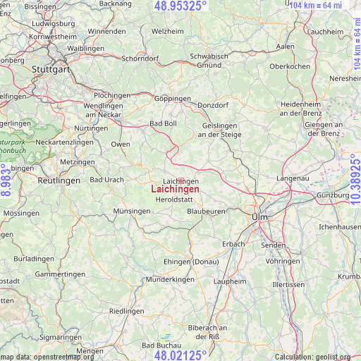
Laichingen GPS coordinates[2]
48° 29' 21.804" North, 9° 41' 10.032" East
| Map corner | latitude | longitude |
|---|---|---|
| Upper-left | 48.95325°, | 8.983° |
| Center: | 48.48939°, | 9.68612° |
| Lower-right: | 48.02125°, | 10.38925° |
| Map W x H: | 103.6×103.6 km | = 64.4×64.4mi |
| max Lat: | 55.01917° ⇑89.3% North |
| Laichingen: | 48.48939° |
| min Lat: | ⇓10.7% South 47.40724° |
| min Long | Laichingen | max Long |
| 5.92978° | 9.68612° | 14.98853° |
| W 45.4%⇐ | ⇒54.6% E |
Elevation
Elevation of Laichingen is 757 m = 2484 ft, and this is 507.9 m = 1666 ft above average elevation for this country.
| Max E: |
1256 m = 4121 ft | 1.2% |
| Laichingen | 757 m 2484 ft | |
| Avg. | 249.1 m = 817 ft | |
Min E: |
-5 m = -16 ft | 98.8% |
See also: Germany elevation on elevation.city.
Geographical zone
Laichingen is located in North temperate zone (between Tropic of Cancer and the Arctic Circle). Distance of this North polar circle is 2009.7 km =1248.8 mi to North.| Distance of | km | miles | from Laichingen |
|---|---|---|---|
| North Pole | 4615.5 | 2867.9 | to North |
| Arctic Circle | 2009.7 | 1248.8 | to North |
| Tropic Cancer | 2785.6 | 1730.9 | to South |
| Equator | 5391.5 | 3350.1 | to South |


Nearby cities:
15 places around Laichingen: (largest is in red/bold)
• Altes Lager
13.6 km =8.5 mi,  234°
234°
• Bad Ditzenbach
11.1 km =6.9 mi,  6°
6°
• Bad Überkingen
14.7 km =9.1 mi,  33°
33°
• Berghülen
6.2 km =3.9 mi,  117°
117°
• Blaubeuren
11.2 km =7 mi,  139°
139°
• Deggingen
12.2 km =7.6 mi, 11°
• Gruibingen
12.1 km =7.5 mi,  345°
345°
• Hohenstadt
6.3 km =3.9 mi, 345°
• Merklingen
5.6 km =3.5 mi,  64°
64°
• Mühlhausen
9.9 km =6.2 mi, 347°
• Neidlingen
13.4 km =8.3 mi,  317°
317°
• Nellingen
9.7 km =6 mi,  52°
52°
• Schelklingen
13.1 km =8.1 mi,  164°
164°
• Westerheim
5.4 km =3.4 mi,  302°
302°
• Wiesensteig
9.2 km =5.7 mi,  330°
330°
Sources, notices
• [Note1] Compared only with cities in Germany existing in our database
• [Src1] Map data: © OpenStreetMap contributors (CC-BY-SA)
• [Src2] Other city data from geonames.org with taken over terms of usage.
• [Src3] Geographical zone / Annual Mean Temperature by Robert A. Rohde @ Wikipedia
