Wetter (Ruhr) geodata
Wetter (Ruhr) (North Rhine-Westphalia) is a populated place; located in Germany in Europe/Berlin (GMT+2) time zone. With population of 29,146 people, there are 485 cities with bigger population in this country. Compared to other cities in Germany, 64.6% of cities are located further ↓South; 88.7% of cities are located further →East and 64.1% of cities have higher elevation than Wetter (Ruhr). Note1
Administrative division(s):
- Level 1: North Rhine-Westphalia
- Level 2: Regierungsbezirk Arnsberg
- Level 3: Ennepe-Ruhr-Kreis
- Level 4: Wetter (Ruhr)


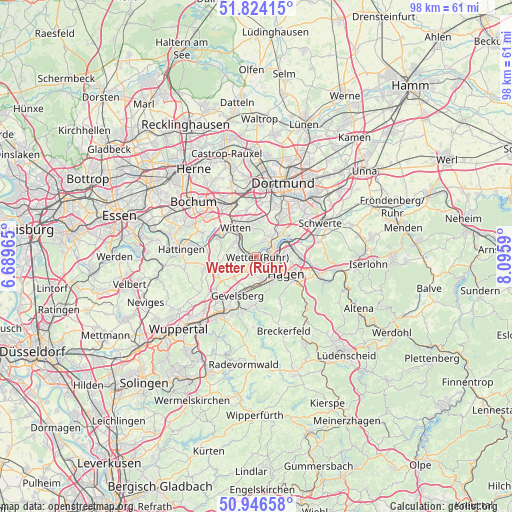
Wetter (Ruhr) GPS coordinates[2]
51° 23' 14.892" North, 7° 23' 33.972" East
| Map corner | latitude | longitude |
|---|---|---|
| Upper-left | 51.82415°, | 6.68965° |
| Center: | 51.38747°, | 7.39277° |
| Lower-right: | 50.94658°, | 8.0959° |
| Map W x H: | 97.6×97.6 km | = 60.6×60.6mi |
| max Lat: | 55.01917° ⇑35.4% North |
| Wetter (Ruhr): | 51.38747° |
| min Lat: | ⇓64.6% South 47.40724° |
| min Long | Wetter (Ruhr) | max Long |
| 5.92978° | 7.39277° | 14.98853° |
| W 11.3%⇐ | ⇒88.7% E |
Elevation
Elevation of Wetter (Ruhr) is 126 m = 413 ft, and this is 123.1 m = 404 ft below average elevation for this country.
| Max E: |
1256 m = 4121 ft | 64.1% |
| Avg. | 249.1 m = 817 ft | |
| Wetter (Ruhr) | 126 m = 413 ft | |
Min E: |
-5 m = -16 ft | 35.9% |
See also: Germany elevation on elevation.city.
Geographical zone
Wetter (Ruhr) is located in North temperate zone (between Tropic of Cancer and the Arctic Circle). Distance of this North polar circle is 1687.4 km =1048.5 mi to North.| Distance of | km | miles | from Wetter (Ruhr) |
|---|---|---|---|
| North Pole | 4293.3 | 2667.7 | to North |
| Arctic Circle | 1687.4 | 1048.5 | to North |
| Tropic Cancer | 3107.8 | 1931.1 | to South |
| Equator | 5713.8 | 3550.4 | to South |


Nearby cities:
15 places around Wetter (Ruhr): (largest is in red/bold)
• Bochum
16.1 km =10 mi,  310°
310°
• Breckerfeld
15.2 km =9.4 mi,  159°
159°
• Dortmund
15.1 km =9.4 mi,  19°
19°
• Ennepetal
10.1 km =6.3 mi,  191°
191°
• Gevelsberg
8.4 km =5.2 mi,  206°
206°
• Hagen
6.2 km =3.9 mi,  118°
118°
• Hattingen
14.4 km =8.9 mi,  275°
275°
• Herdecke
3.3 km =2.1 mi,  65°
65°
• Hordel
19.4 km =12.1 mi, 309°
• Nachrodt-Wiblingwerde
17.4 km =10.8 mi, 116°
• Schalksmühle
18.8 km =11.7 mi,  149°
149°
• Schwelm
13.2 km =8.2 mi, 211°
• Schwerte
13.6 km =8.5 mi,  62°
62°
• Sprockhövel
11.3 km =7 mi,  246°
246°
• Witten
6.8 km =4.2 mi,  335°
335°
Sources, notices
• [Note1] Compared only with cities in Germany existing in our database
• [Src1] Map data: © OpenStreetMap contributors (CC-BY-SA)
• [Src2] Other city data from geonames.org with taken over terms of usage.
• [Src3] Geographical zone / Annual Mean Temperature by Robert A. Rohde @ Wikipedia
