Sprockhövel geodata
Sprockhövel (North Rhine-Westphalia) is a populated place; located in Germany in Europe/Berlin (GMT+2) time zone. With population of 26,400 people, there are 548 cities with bigger population in this country. Compared to other cities in Germany, 63.9% of cities are located further ↓South; 90.8% of cities are located further →East and 50.3% of cities have lower elevation than Sprockhövel. Note1
Administrative division(s):
- Level 1: North Rhine-Westphalia
- Level 2: Regierungsbezirk Arnsberg
- Level 3: Ennepe-Ruhr-Kreis
- Level 4: Sprockhövel


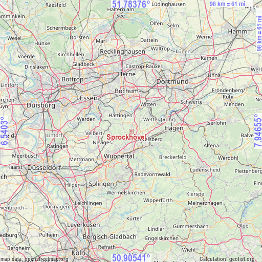
Sprockhövel GPS coordinates[2]
51° 20' 48.084" North, 7° 14' 36.348" East
| Map corner | latitude | longitude |
|---|---|---|
| Upper-left | 51.78376°, | 6.5403° |
| Center: | 51.34669°, | 7.24343° |
| Lower-right: | 50.90541°, | 7.94655° |
| Map W x H: | 97.7×97.7 km | = 60.7×60.7mi |
| max Lat: | 55.01917° ⇑36.1% North |
| Sprockhövel: | 51.34669° |
| min Lat: | ⇓63.9% South 47.40724° |
| min Long | Sprockhövel | max Long |
| 5.92978° | 7.24343° | 14.98853° |
| W 9.2%⇐ | ⇒90.8% E |
Elevation
Elevation of Sprockhövel is 228 m = 748 ft, and this is 21.1 m = 69 ft below average elevation for this country.
| Max E: |
1256 m = 4121 ft | 49.7% |
| Avg. | 249.1 m = 817 ft | |
| Sprockhövel | 228 m = 748 ft | |
Min E: |
-5 m = -16 ft | 50.3% |
See also: Germany elevation on elevation.city.
Geographical zone
Sprockhövel is located in North temperate zone (between Tropic of Cancer and the Arctic Circle). Distance of this North polar circle is 1692 km =1051.4 mi to North.| Distance of | km | miles | from Sprockhövel |
|---|---|---|---|
| North Pole | 4297.8 | 2670.5 | to North |
| Arctic Circle | 1692 | 1051.4 | to North |
| Tropic Cancer | 3103.3 | 1928.3 | to South |
| Equator | 5709.2 | 3547.5 | to South |


Nearby cities:
15 places around Sprockhövel: (largest is in red/bold)
• Bochum
15.1 km =9.4 mi,  352°
352°
• Bochum-Hordel
17.9 km =11.1 mi,  344°
344°
• Ennepetal
9.9 km =6.2 mi,  122°
122°
• Gevelsberg
7.3 km =4.5 mi,  114°
114°
• Hagen
15.9 km =9.9 mi,  84°
84°
• Hattingen
7.1 km =4.4 mi,  325°
325°
• Herdecke
14.6 km =9.1 mi,  66°
66°
• Hordel
17.4 km =10.8 mi, 344°
• Radevormwald
18 km =11.2 mi,  153°
153°
• Schwelm
7.6 km =4.7 mi, 152°
• Velbert
13.9 km =8.6 mi,  264°
264°
• Wetter (Ruhr)
11.3 km =7 mi, 66°
• Witten
13.2 km =8.2 mi,  35°
35°
• Wuppertal
12 km =7.5 mi,  213°
213°
• Wülfrath
16 km =9.9 mi,  243°
243°
Sources, notices
• [Note1] Compared only with cities in Germany existing in our database
• [Src1] Map data: © OpenStreetMap contributors (CC-BY-SA)
• [Src2] Other city data from geonames.org with taken over terms of usage.
• [Src3] Geographical zone / Annual Mean Temperature by Robert A. Rohde @ Wikipedia
