Hattingen geodata
Hattingen (North Rhine-Westphalia) is a populated place; located in Germany in Europe/Berlin (GMT+2) time zone. With population of 56,866 people, there are 188 cities with bigger population in this country. Compared to other cities in Germany, 64.7% of cities are located further ↓South; 91.5% of cities are located further →East and 68.5% of cities have higher elevation than Hattingen. Note1
Administrative division(s):
- Level 1: North Rhine-Westphalia
- Level 2: Regierungsbezirk Arnsberg
- Level 3: Ennepe-Ruhr-Kreis
- Level 4: Hattingen


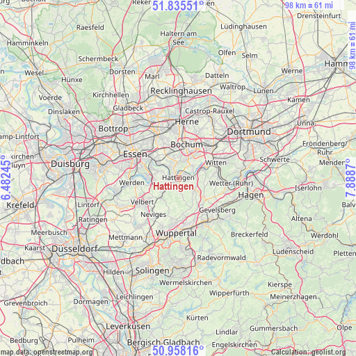
Hattingen GPS coordinates[2]
51° 23' 56.184" North, 7° 11' 8.052" East
| Map corner | latitude | longitude |
|---|---|---|
| Upper-left | 51.83551°, | 6.48245° |
| Center: | 51.39894°, | 7.18557° |
| Lower-right: | 50.95816°, | 7.8887° |
| Map W x H: | 97.6×97.6 km | = 60.6×60.6mi |
| max Lat: | 55.01917° ⇑35.3% North |
| Hattingen: | 51.39894° |
| min Lat: | ⇓64.7% South 47.40724° |
| min Long | Hattingen | max Long |
| 5.92978° | 7.18557° | 14.98853° |
| W 8.5%⇐ | ⇒91.5% E |
Elevation
Elevation of Hattingen is 100 m = 328 ft, and this is 149.1 m = 489 ft below average elevation for this country.
| Max E: |
1256 m = 4121 ft | 68.5% |
| Avg. | 249.1 m = 817 ft | |
| Hattingen | 100 m = 328 ft | |
Min E: |
-5 m = -16 ft | 31.5% |
See also: Hattingen elevation on elevation.city.
Geographical zone
Hattingen is located in North temperate zone (between Tropic of Cancer and the Arctic Circle). Distance of this North polar circle is 1686.1 km =1047.7 mi to North.| Distance of | km | miles | from Hattingen |
|---|---|---|---|
| North Pole | 4292 | 2666.9 | to North |
| Arctic Circle | 1686.1 | 1047.7 | to North |
| Tropic Cancer | 3109.1 | 1931.9 | to South |
| Equator | 5715 | 3551.1 | to South |


Nearby cities:
15 places around Hattingen: (largest is in red/bold)
• Bochum
9.4 km =5.8 mi,  13°
13°
• Bochum-Hordel
11.4 km =7.1 mi,  356°
356°
• Ennepetal
16.6 km =10.3 mi,  132°
132°
• Essen
13.6 km =8.5 mi,  298°
298°
• Gelsenkirchen
13.3 km =8.3 mi,  332°
332°
• Gevelsberg
13.8 km =8.6 mi, 129°
• Herne
15.8 km =9.8 mi, 10°
• Hordel
11 km =6.8 mi, 356°
• Schwelm
14.6 km =9.1 mi,  148°
148°
• Sprockhövel
7.1 km =4.4 mi, 145°
• Velbert
12.1 km =7.5 mi,  234°
234°
• Wetter (Ruhr)
14.4 km =8.9 mi,  95°
95°
• Witten
12.6 km =7.8 mi,  66°
66°
• Wuppertal
16.1 km =10 mi,  189°
189°
• Wülfrath
16.6 km =10.3 mi,  218°
218°
Sources, notices
• [Note1] Compared only with cities in Germany existing in our database
• [Src1] Map data: © OpenStreetMap contributors (CC-BY-SA)
• [Src2] Other city data from geonames.org with taken over terms of usage.
• [Src3] Geographical zone / Annual Mean Temperature by Robert A. Rohde @ Wikipedia
