Schalksmühle geodata
Schalksmühle (North Rhine-Westphalia) is a seat of a fourth-order administrative division; located in Germany in Europe/Berlin (GMT+2) time zone. With population of 11,753 people, there are 1396 cities with bigger population in this country. Compared to other cities in Germany, 62.2% of cities are located further ↓South; 86.5% of cities are located further →East and 54.2% of cities have lower elevation than Schalksmühle. Note1
Administrative division(s):
- Level 1: North Rhine-Westphalia
- Level 2: Regierungsbezirk Arnsberg
- Level 3: Märkischer Kreis
- Level 4: Schalksmühle


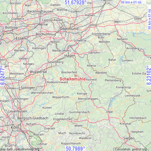
Schalksmühle GPS coordinates[2]
51° 14' 28.32" North, 7° 31' 40.44" East
| Map corner | latitude | longitude |
|---|---|---|
| Upper-left | 51.67928°, | 6.82477° |
| Center: | 51.2412°, | 7.5279° |
| Lower-right: | 50.7989°, | 8.23102° |
| Map W x H: | 97.9×97.9 km | = 60.8×60.8mi |
| max Lat: | 55.01917° ⇑37.8% North |
| Schalksmühle: | 51.2412° |
| min Lat: | ⇓62.2% South 47.40724° |
| min Long | Schalksmühle | max Long |
| 5.92978° | 7.5279° | 14.98853° |
| W 13.5%⇐ | ⇒86.5% E |
Elevation
Elevation of Schalksmühle is 253 m = 830 ft, and this is 3.9 m = 13 ft above average elevation for this country.
| Max E: |
1256 m = 4121 ft | 45.8% |
| Schalksmühle | 253 m 830 ft | |
| Avg. | 249.1 m = 817 ft | |
Min E: |
-5 m = -16 ft | 54.2% |
See also: Germany elevation on elevation.city.
Geographical zone
Schalksmühle is located in North temperate zone (between Tropic of Cancer and the Arctic Circle). Distance of this North polar circle is 1703.7 km =1058.6 mi to North.| Distance of | km | miles | from Schalksmühle |
|---|---|---|---|
| North Pole | 4309.6 | 2677.9 | to North |
| Arctic Circle | 1703.7 | 1058.6 | to North |
| Tropic Cancer | 3091.6 | 1921 | to South |
| Equator | 5697.5 | 3540.3 | to South |


Nearby cities:
15 places around Schalksmühle: (largest is in red/bold)
• Altena
11.7 km =7.3 mi,  59°
59°
• Breckerfeld
4.6 km =2.9 mi,  295°
295°
• Ennepetal
13.1 km =8.1 mi, 299°
• Gevelsberg
15.8 km =9.8 mi, 303°
• Hagen
13.9 km =8.6 mi,  343°
343°
• Halver
6.5 km =4 mi,  198°
198°
• Herscheid
16.5 km =10.3 mi,  114°
114°
• Hückeswagen
16.3 km =10.1 mi,  231°
231°
• Kierspe
12.7 km =7.9 mi,  159°
159°
• Lüdenscheid
7.3 km =4.5 mi, 108°
• Nachrodt-Wiblingwerde
10.4 km =6.5 mi,  36°
36°
• Radevormwald
12.5 km =7.8 mi,  249°
249°
• Schwelm
17 km =10.6 mi,  287°
287°
• Werdohl
16.7 km =10.4 mi,  82°
82°
• Wipperfürth
16.6 km =10.3 mi,  212°
212°
Sources, notices
• [Note1] Compared only with cities in Germany existing in our database
• [Src1] Map data: © OpenStreetMap contributors (CC-BY-SA)
• [Src2] Other city data from geonames.org with taken over terms of usage.
• [Src3] Geographical zone / Annual Mean Temperature by Robert A. Rohde @ Wikipedia
