Witten geodata
Witten (North Rhine-Westphalia) is a populated place; located in Germany in Europe/Berlin (GMT+2) time zone. With population of 101,247 people, there are 96 cities with bigger population in this country. Compared to other cities in Germany, 65.5% of cities are located further ↓South; 89.1% of cities are located further →East and 65.2% of cities have higher elevation than Witten. Note1
Administrative division(s):
- Level 1: North Rhine-Westphalia
- Level 2: Regierungsbezirk Arnsberg
- Level 3: Ennepe-Ruhr-Kreis
- Level 4: Witten


Witten GPS coordinates[2]
51° 26' 37.032" North, 7° 21' 9.288" East
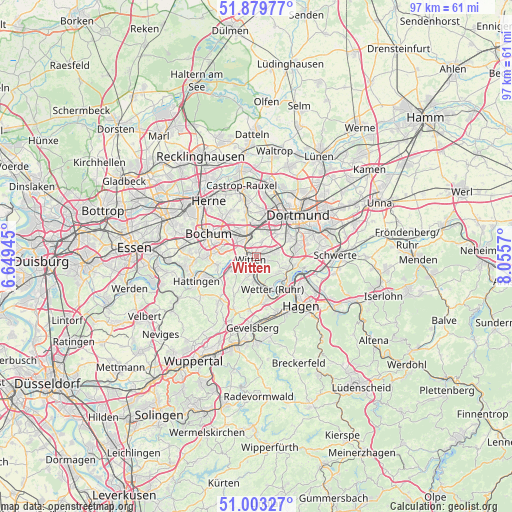
| Map corner | latitude | longitude |
|---|---|---|
| Upper-left | 51.87977°, | 6.64945° |
| Center: | 51.44362°, | 7.35258° |
| Lower-right: | 51.00327°, | 8.0557° |
| Map W x H: | 97.5×97.5 km | = 60.6×60.6mi |
| max Lat: | 55.01917° ⇑34.5% North |
| Witten: | 51.44362° |
| min Lat: | ⇓65.5% South 47.40724° |
| min Long | Witten | max Long |
| 5.92978° | 7.35258° | 14.98853° |
| W 10.9%⇐ | ⇒89.1% E |
Elevation
Elevation of Witten is 119 m = 390 ft, and this is 130.1 m = 427 ft below average elevation for this country.
| Max E: |
1256 m = 4121 ft | 65.2% |
| Avg. | 249.1 m = 817 ft | |
| Witten | 119 m = 390 ft | |
Min E: |
-5 m = -16 ft | 34.8% |
See also: Witten elevation on elevation.city.
Geographical zone
Witten is located in North temperate zone (between Tropic of Cancer and the Arctic Circle). Distance of this North polar circle is 1681.2 km =1044.6 mi to North.| Distance of | km | miles | from Witten |
|---|---|---|---|
| North Pole | 4287.1 | 2663.9 | to North |
| Arctic Circle | 1681.2 | 1044.6 | to North |
| Tropic Cancer | 3114.1 | 1935 | to South |
| Equator | 5720 | 3554.2 | to South |


Nearby cities:
15 places around Witten: (largest is in red/bold)
• Bochum
10.3 km =6.4 mi,  294°
294°
• Bochum-Hordel
13.9 km =8.6 mi,  297°
297°
• Castrop-Rauxel
12.9 km =8 mi,  347°
347°
• Dortmund
11.2 km =7 mi,  44°
44°
• Ennepetal
16.2 km =10.1 mi,  177°
177°
• Gevelsberg
13.8 km =8.6 mi, 183°
• Hagen
12.4 km =7.7 mi,  138°
138°
• Hattingen
12.6 km =7.8 mi,  246°
246°
• Herdecke
7.5 km =4.7 mi,  130°
130°
• Herne
13.8 km =8.6 mi,  320°
320°
• Hordel
13.6 km =8.5 mi, 296°
• Schwelm
18 km =11.2 mi,  193°
193°
• Schwerte
14.9 km =9.3 mi,  89°
89°
• Sprockhövel
13.2 km =8.2 mi,  215°
215°
• Wetter (Ruhr)
6.8 km =4.2 mi,  155°
155°
Sources, notices
• [Note1] Compared only with cities in Germany existing in our database
• [Src1] Map data: © OpenStreetMap contributors (CC-BY-SA)
• [Src2] Other city data from geonames.org with taken over terms of usage.
• [Src3] Geographical zone / Annual Mean Temperature by Robert A. Rohde @ Wikipedia
