Westheim geodata
Westheim (Bavaria) is a seat of a fourth-order administrative division; located in Germany in Europe/Berlin (GMT+2) time zone. With population of 1,215 people, there are 6522 cities with bigger population in this country. Compared to other cities in Germany, 83.1% of cities are located further ↑North; 61.9% of cities are located further ←West and 82.7% of cities have lower elevation than Westheim. Note1
Administrative division(s):
- Level 1: Bavaria
- Level 2: Regierungsbezirk Mittelfranken
- Level 3: Landkreis Weißenburg-Gunzenhausen
- Level 4: Westheim


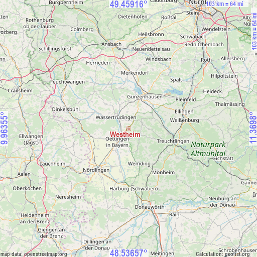
Westheim GPS coordinates[2]
49° 0' 0" North, 10° 40' 0.012" East
| Map corner | latitude | longitude |
|---|---|---|
| Upper-left | 49.45916°, | 9.96355° |
| Center: | 49°, | 10.66667° |
| Lower-right: | 48.53657°, | 11.3698° |
| Map W x H: | 102.6×102.6 km | = 63.8×63.8mi |
| max Lat: | 55.01917° ⇑83.1% North |
| Westheim: | 49° |
| min Lat: | ⇓16.9% South 47.40724° |
| min Long | Westheim | max Long |
| 5.92978° | 10.66667° | 14.98853° |
| W 61.9%⇐ | ⇒38.1% E |
Elevation
Elevation of Westheim is 451 m = 1480 ft, and this is 201.9 m = 662 ft above average elevation for this country.
| Max E: |
1256 m = 4121 ft | 17.3% |
| Westheim | 451 m 1480 ft | |
| Avg. | 249.1 m = 817 ft | |
Min E: |
-5 m = -16 ft | 82.7% |
See also: Germany elevation on elevation.city.
Geographical zone
Westheim is located in North temperate zone (between Tropic of Cancer and the Arctic Circle). Distance of this North polar circle is 1952.9 km =1213.5 mi to North.| Distance of | km | miles | from Westheim |
|---|---|---|---|
| North Pole | 4558.8 | 2832.7 | to North |
| Arctic Circle | 1952.9 | 1213.5 | to North |
| Tropic Cancer | 2842.4 | 1766.2 | to South |
| Equator | 5448.3 | 3385.4 | to South |


Nearby cities:
15 places around Westheim: (largest is in red/bold)
• Auhausen
3.3 km =2.1 mi,  285°
285°
• Dittenheim
11 km =6.8 mi,  56°
56°
• Gerolfingen
12.8 km =8 mi,  297°
297°
• Gnotzheim
7.4 km =4.6 mi,  26°
26°
• Hainsfarth
5.5 km =3.4 mi,  213°
213°
• Heidenheim
5.9 km =3.7 mi,  71°
71°
• Megesheim
7.5 km =4.7 mi,  189°
189°
• Meinheim
11.5 km =7.1 mi, 71°
• Munningen
10.5 km =6.5 mi, 207°
• Oettingen in Bayern
6.9 km =4.3 mi,  220°
220°
• Polsingen
9.4 km =5.8 mi,  159°
159°
• Röckingen
9.9 km =6.2 mi,  308°
308°
• Unterschwaningen
9.5 km =5.9 mi,  339°
339°
• Wassertrüdingen
6.9 km =4.3 mi, 314°
• Wechingen
12.6 km =7.8 mi,  198°
198°
Sources, notices
• [Note1] Compared only with cities in Germany existing in our database
• [Src1] Map data: © OpenStreetMap contributors (CC-BY-SA)
• [Src2] Other city data from geonames.org with taken over terms of usage.
• [Src3] Geographical zone / Annual Mean Temperature by Robert A. Rohde @ Wikipedia
