Wassertrüdingen geodata
Wassertrüdingen (Bavaria) is a populated place; located in Germany in Europe/Berlin (GMT+2) time zone. With population of 6,245 people, there are 2385 cities with bigger population in this country. Compared to other cities in Germany, 82.5% of cities are located further ↑North; 60.7% of cities are located further ←West and 79% of cities have lower elevation than Wassertrüdingen. Note1
Administrative division(s):
- Level 1: Bavaria
- Level 2: Regierungsbezirk Mittelfranken
- Level 3: Landkreis Ansbach
- Level 4: Wassertrüdingen


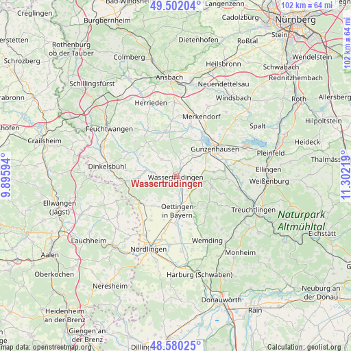
Wassertrüdingen GPS coordinates[2]
49° 2' 35.808" North, 10° 35' 56.616" East
| Map corner | latitude | longitude |
|---|---|---|
| Upper-left | 49.50204°, | 9.89594° |
| Center: | 49.04328°, | 10.59906° |
| Lower-right: | 48.58025°, | 11.30219° |
| Map W x H: | 102.5×102.5 km | = 63.7×63.7mi |
| max Lat: | 55.01917° ⇑82.5% North |
| Wassertrüdingen: | 49.04328° |
| min Lat: | ⇓17.5% South 47.40724° |
| min Long | Wassertrüdinge | max Long |
| 5.92978° | 10.59906° | 14.98853° |
| W 60.7%⇐ | ⇒39.3% E |
Elevation
Elevation of Wassertrüdingen is 427 m = 1401 ft, and this is 177.9 m = 584 ft above average elevation for this country.
| Max E: |
1256 m = 4121 ft | 21% |
| Wassertrüdingen | 427 m 1401 ft | |
| Avg. | 249.1 m = 817 ft | |
Min E: |
-5 m = -16 ft | 79% |
See also: Germany elevation on elevation.city.
Geographical zone
Wassertrüdingen is located in North temperate zone (between Tropic of Cancer and the Arctic Circle). Distance of this North polar circle is 1948.1 km =1210.5 mi to North.| Distance of | km | miles | from Wassertrüdingen |
|---|---|---|---|
| North Pole | 4554 | 2829.7 | to North |
| Arctic Circle | 1948.1 | 1210.5 | to North |
| Tropic Cancer | 2847.2 | 1769.2 | to South |
| Equator | 5453.1 | 3388.4 | to South |


Nearby cities:
15 places around Wassertrüdingen: (largest is in red/bold)
• Arberg
11.3 km =7 mi,  6°
6°
• Auhausen
4.3 km =2.7 mi,  156°
156°
• Ehingen
6.4 km =4 mi,  318°
318°
• Gerolfingen
6.5 km =4 mi,  280°
280°
• Gnotzheim
8.5 km =5.3 mi,  77°
77°
• Hainsfarth
9.6 km =6 mi,  168°
168°
• Heidenheim
10.9 km =6.8 mi,  105°
105°
• Langfurth
12.4 km =7.7 mi,  301°
301°
• Megesheim
12.8 km =8 mi, 163°
• Oettingen in Bayern
10.1 km =6.3 mi,  177°
177°
• Röckingen
3.2 km =2 mi, 295°
• Unterschwaningen
4.4 km =2.7 mi,  22°
22°
• Weiltingen
10.8 km =6.7 mi,  267°
267°
• Westheim
6.9 km =4.3 mi,  134°
134°
• Wittelshofen
8.8 km =5.5 mi, 283°
Sources, notices
• [Note1] Compared only with cities in Germany existing in our database
• [Src1] Map data: © OpenStreetMap contributors (CC-BY-SA)
• [Src2] Other city data from geonames.org with taken over terms of usage.
• [Src3] Geographical zone / Annual Mean Temperature by Robert A. Rohde @ Wikipedia
