Röckingen geodata
Röckingen (Bavaria) is a seat of a fourth-order administrative division; located in Germany in Europe/Berlin (GMT+2) time zone. With population of 789 people, there are 7949 cities with bigger population in this country. Compared to other cities in Germany, 82.3% of cities are located further ↑North; 60% of cities are located further ←West and 82.3% of cities have lower elevation than Röckingen. Note1
Administrative division(s):
- Level 1: Bavaria
- Level 2: Regierungsbezirk Mittelfranken
- Level 3: Landkreis Ansbach
- Level 4: Röckingen


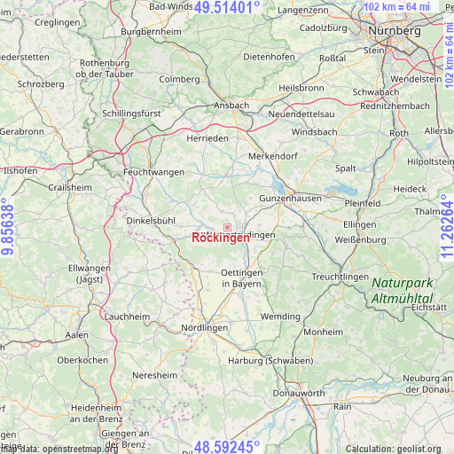
Röckingen GPS coordinates[2]
49° 3' 19.332" North, 10° 33' 34.236" East
| Map corner | latitude | longitude |
|---|---|---|
| Upper-left | 49.51401°, | 9.85638° |
| Center: | 49.05537°, | 10.55951° |
| Lower-right: | 48.59245°, | 11.26264° |
| Map W x H: | 102.5×102.5 km | = 63.7×63.7mi |
| max Lat: | 55.01917° ⇑82.3% North |
| Röckingen: | 49.05537° |
| min Lat: | ⇓17.7% South 47.40724° |
| min Long | Röckingen | max Long |
| 5.92978° | 10.55951° | 14.98853° |
| W 60%⇐ | ⇒40% E |
Elevation
Elevation of Röckingen is 448 m = 1470 ft, and this is 198.9 m = 653 ft above average elevation for this country.
| Max E: |
1256 m = 4121 ft | 17.7% |
| Röckingen | 448 m 1470 ft | |
| Avg. | 249.1 m = 817 ft | |
Min E: |
-5 m = -16 ft | 82.3% |
See also: Germany elevation on elevation.city.
Geographical zone
Röckingen is located in North temperate zone (between Tropic of Cancer and the Arctic Circle). Distance of this North polar circle is 1946.7 km =1209.6 mi to North.| Distance of | km | miles | from Röckingen |
|---|---|---|---|
| North Pole | 4552.6 | 2828.9 | to North |
| Arctic Circle | 1946.7 | 1209.6 | to North |
| Tropic Cancer | 2848.5 | 1770 | to South |
| Equator | 5454.4 | 3389.2 | to South |


Nearby cities:
15 places around Röckingen: (largest is in red/bold)
• Arberg
10.7 km =6.6 mi,  23°
23°
• Auhausen
7 km =4.3 mi,  139°
139°
• Burk
10.5 km =6.5 mi,  325°
325°
• Ehingen
3.8 km =2.4 mi,  338°
338°
• Fremdingen
11.8 km =7.3 mi,  218°
218°
• Gerolfingen
3.5 km =2.2 mi,  266°
266°
• Gnotzheim
11.2 km =7 mi,  87°
87°
• Hainsfarth
11.8 km =7.3 mi,  156°
156°
• Langfurth
9.2 km =5.7 mi,  303°
303°
• Oettingen in Bayern
11.9 km =7.4 mi, 163°
• Unterschwaningen
5.3 km =3.3 mi,  59°
59°
• Wassertrüdingen
3.2 km =2 mi,  115°
115°
• Weiltingen
8.2 km =5.1 mi,  256°
256°
• Westheim
9.9 km =6.2 mi,  128°
128°
• Wittelshofen
5.7 km =3.5 mi,  276°
276°
Sources, notices
• [Note1] Compared only with cities in Germany existing in our database
• [Src1] Map data: © OpenStreetMap contributors (CC-BY-SA)
• [Src2] Other city data from geonames.org with taken over terms of usage.
• [Src3] Geographical zone / Annual Mean Temperature by Robert A. Rohde @ Wikipedia
