Werne geodata
Werne (North Rhine-Westphalia) is a populated place; located in Germany in Europe/Berlin (GMT+2) time zone. With population of 30,810 people, there are 451 cities with bigger population in this country. Compared to other cities in Germany, 68.5% of cities are located further ↓South; 84.2% of cities are located further →East and 75.8% of cities have higher elevation than Werne. Note1
Administrative division(s):
- Level 1: North Rhine-Westphalia
- Level 2: Regierungsbezirk Arnsberg
- Level 3: Kreis Unna
- Level 4: Werne


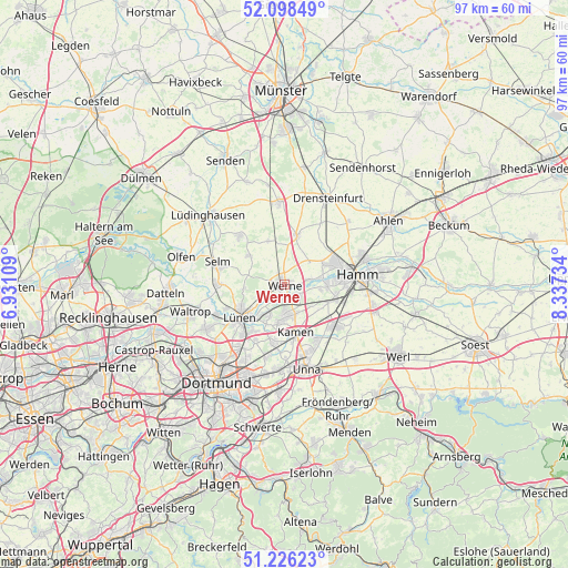
Werne GPS coordinates[2]
51° 39' 52.056" North, 7° 38' 3.156" East
| Map corner | latitude | longitude |
|---|---|---|
| Upper-left | 52.09849°, | 6.93109° |
| Center: | 51.66446°, | 7.63421° |
| Lower-right: | 51.22623°, | 8.33734° |
| Map W x H: | 97×97 km | = 60.3×60.3mi |
| max Lat: | 55.01917° ⇑31.5% North |
| Werne: | 51.66446° |
| min Lat: | ⇓68.5% South 47.40724° |
| min Long | Werne | max Long |
| 5.92978° | 7.63421° | 14.98853° |
| W 15.8%⇐ | ⇒84.2% E |
Elevation
Elevation of Werne is 60 m = 197 ft, and this is 189.1 m = 620 ft below average elevation for this country.
| Max E: |
1256 m = 4121 ft | 75.8% |
| Avg. | 249.1 m = 817 ft | |
| Werne | 60 m = 197 ft | |
Min E: |
-5 m = -16 ft | 24.2% |
See also: Germany elevation on elevation.city.
Geographical zone
Werne is located in North temperate zone (between Tropic of Cancer and the Arctic Circle). Distance of this North polar circle is 1656.6 km =1029.4 mi to North.| Distance of | km | miles | from Werne |
|---|---|---|---|
| North Pole | 4262.5 | 2648.6 | to North |
| Arctic Circle | 1656.6 | 1029.4 | to North |
| Tropic Cancer | 3138.6 | 1950.2 | to South |
| Equator | 5744.5 | 3569.5 | to South |


Nearby cities:
15 places around Werne: (largest is in red/bold)
• Ascheberg
13.3 km =8.3 mi,  354°
354°
• Bergkamen
5.4 km =3.4 mi,  172°
172°
• Bönen
11.6 km =7.2 mi,  128°
128°
• Drensteinfurt
16.2 km =10.1 mi,  26°
26°
• Hamm
13 km =8.1 mi,  82°
82°
• Holzwickede
18.3 km =11.4 mi,  180°
180°
• Kamen
8.3 km =5.2 mi, 165°
• Lanstrop
11 km =6.8 mi,  204°
204°
• Lüdinghausen
17.5 km =10.9 mi,  311°
311°
• Lünen
9 km =5.6 mi,  233°
233°
• Nordkirchen
11.3 km =7 mi,  316°
316°
• Olfen
18.2 km =11.3 mi,  285°
285°
• Selm
12 km =7.5 mi, 287°
• Unna
14.6 km =9.1 mi,  164°
164°
• Waltrop
16.7 km =10.4 mi,  253°
253°
Sources, notices
• [Note1] Compared only with cities in Germany existing in our database
• [Src1] Map data: © OpenStreetMap contributors (CC-BY-SA)
• [Src2] Other city data from geonames.org with taken over terms of usage.
• [Src3] Geographical zone / Annual Mean Temperature by Robert A. Rohde @ Wikipedia
