Ascheberg geodata
Ascheberg (North Rhine-Westphalia) is a seat of a fourth-order administrative division; located in Germany in Europe/Berlin (GMT+2) time zone. With population of 15,184 people, there are 1057 cities with bigger population in this country. Compared to other cities in Germany, 69.7% of cities are located further ↓South; 84.8% of cities are located further →East and 73.8% of cities have higher elevation than Ascheberg. Note1
Administrative division(s):
- Level 1: North Rhine-Westphalia
- Level 2: Regierungsbezirk Münster
- Level 3: Kreis Coesfeld
- Level 4: Ascheberg


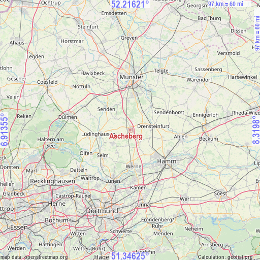
Ascheberg GPS coordinates[2]
51° 46' 59.988" North, 7° 37' 0.012" East
| Map corner | latitude | longitude |
|---|---|---|
| Upper-left | 52.21621°, | 6.91355° |
| Center: | 51.78333°, | 7.61667° |
| Lower-right: | 51.34625°, | 8.3198° |
| Map W x H: | 96.7×96.7 km | = 60.1×60.1mi |
| max Lat: | 55.01917° ⇑30.3% North |
| Ascheberg: | 51.78333° |
| min Lat: | ⇓69.7% South 47.40724° |
| min Long | Ascheberg | max Long |
| 5.92978° | 7.61667° | 14.98853° |
| W 15.2%⇐ | ⇒84.8% E |
Elevation
Elevation of Ascheberg is 68 m = 223 ft, and this is 181.1 m = 594 ft below average elevation for this country.
| Max E: |
1256 m = 4121 ft | 73.8% |
| Avg. | 249.1 m = 817 ft | |
| Ascheberg | 68 m = 223 ft | |
Min E: |
-5 m = -16 ft | 26.2% |
See also: Germany elevation on elevation.city.
Geographical zone
Ascheberg is located in North temperate zone (between Tropic of Cancer and the Arctic Circle). Distance of this North polar circle is 1643.4 km =1021.2 mi to North.| Distance of | km | miles | from Ascheberg |
|---|---|---|---|
| North Pole | 4249.3 | 2640.4 | to North |
| Arctic Circle | 1643.4 | 1021.2 | to North |
| Tropic Cancer | 3151.8 | 1958.4 | to South |
| Equator | 5757.8 | 3577.7 | to South |


Nearby cities:
15 places around Ascheberg: (largest is in red/bold)
• Ahlen
18.8 km =11.7 mi,  96°
96°
• Bergkamen
18.7 km =11.6 mi,  174°
174°
• Drensteinfurt
8.5 km =5.3 mi,  80°
80°
• Everswinkel
22.4 km =13.9 mi,  44°
44°
• Hamm
18.1 km =11.2 mi,  129°
129°
• Kamen
21.5 km =13.4 mi, 171°
• Lüdinghausen
12 km =7.5 mi,  262°
262°
• Lünen
19.5 km =12.1 mi,  198°
198°
• Münster
19.9 km =12.4 mi,  1°
1°
• Nordkirchen
8.2 km =5.1 mi,  232°
232°
• Olfen
18.4 km =11.4 mi,  242°
242°
• Selm
14 km =8.7 mi, 226°
• Senden
12.3 km =7.6 mi,  311°
311°
• Sendenhorst
16.1 km =10 mi,  65°
65°
• Werne
13.3 km =8.3 mi, 174°
Sources, notices
• [Note1] Compared only with cities in Germany existing in our database
• [Src1] Map data: © OpenStreetMap contributors (CC-BY-SA)
• [Src2] Other city data from geonames.org with taken over terms of usage.
• [Src3] Geographical zone / Annual Mean Temperature by Robert A. Rohde @ Wikipedia
