Weissach geodata
Weissach (Baden-Württemberg) is a populated place; located in Germany in Europe/Berlin (GMT+2) time zone. With population of 7,712 people, there are 2007 cities with bigger population in this country. Compared to other cities in Germany, 84.7% of cities are located further ↑North; 66.3% of cities are located further →East and 70% of cities have lower elevation than Weissach. Note1
Administrative division(s):
- Level 1: Baden-Württemberg
- Level 2: Regierungsbezirk Stuttgart
- Level 3: Landkreis Böblingen
- Level 4: Weissach


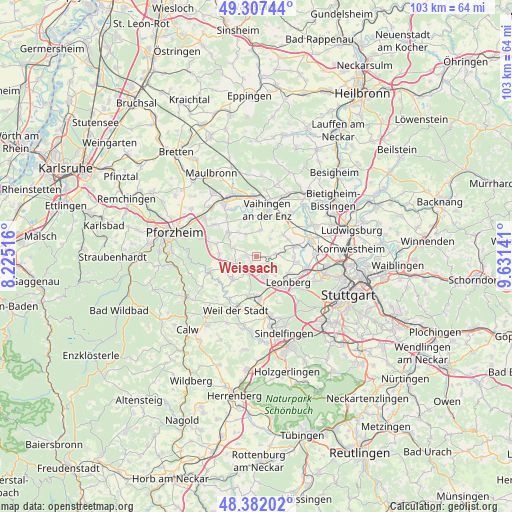
Weissach GPS coordinates[2]
48° 50' 48.732" North, 8° 55' 41.808" East
| Map corner | latitude | longitude |
|---|---|---|
| Upper-left | 49.30744°, | 8.22516° |
| Center: | 48.84687°, | 8.92828° |
| Lower-right: | 48.38202°, | 9.63141° |
| Map W x H: | 102.9×102.9 km | = 63.9×63.9mi |
| max Lat: | 55.01917° ⇑84.7% North |
| Weissach: | 48.84687° |
| min Lat: | ⇓15.3% South 47.40724° |
| min Long | Weissach | max Long |
| 5.92978° | 8.92828° | 14.98853° |
| W 33.7%⇐ | ⇒66.3% E |
Elevation
Elevation of Weissach is 358 m = 1175 ft, and this is 108.9 m = 357 ft above average elevation for this country.
| Max E: |
1256 m = 4121 ft | 30% |
| Weissach | 358 m 1175 ft | |
| Avg. | 249.1 m = 817 ft | |
Min E: |
-5 m = -16 ft | 70% |
See also: Germany elevation on elevation.city.
Geographical zone
Weissach is located in North temperate zone (between Tropic of Cancer and the Arctic Circle). Distance of this North polar circle is 1969.9 km =1224 mi to North.| Distance of | km | miles | from Weissach |
|---|---|---|---|
| North Pole | 4575.8 | 2843.3 | to North |
| Arctic Circle | 1969.9 | 1224 | to North |
| Tropic Cancer | 2825.3 | 1755.6 | to South |
| Equator | 5431.3 | 3374.9 | to South |


Nearby cities:
15 places around Weissach: (largest is in red/bold)
• Ditzingen
10.4 km =6.5 mi,  102°
102°
• Eberdingen
4.5 km =2.8 mi,  36°
36°
• Friolzheim
7.1 km =4.4 mi,  257°
257°
• Heimsheim
6.3 km =3.9 mi,  224°
224°
• Hemmingen
8 km =5 mi,  74°
74°
• Leonberg
8.3 km =5.2 mi,  128°
128°
• Mönsheim
5 km =3.1 mi,  296°
296°
• Renningen
8.6 km =5.3 mi,  174°
174°
• Rutesheim
4.5 km =2.8 mi,  163°
163°
• Schwieberdingen
11.2 km =7 mi, 72°
• Tiefenbronn
9.6 km =6 mi,  254°
254°
• Vaihingen an der Enz
10.1 km =6.3 mi,  13°
13°
• Wiernsheim
7 km =4.3 mi,  305°
305°
• Wimsheim
7 km =4.3 mi,  272°
272°
• Wurmberg
8.5 km =5.3 mi,  285°
285°
Sources, notices
• [Note1] Compared only with cities in Germany existing in our database
• [Src1] Map data: © OpenStreetMap contributors (CC-BY-SA)
• [Src2] Other city data from geonames.org with taken over terms of usage.
• [Src3] Geographical zone / Annual Mean Temperature by Robert A. Rohde @ Wikipedia
