Hemmingen geodata
Hemmingen (Baden-Württemberg) is a seat of a fourth-order administrative division; located in Germany in Europe/Berlin (GMT+2) time zone. With population of 7,670 people, there are 2019 cities with bigger population in this country. Compared to other cities in Germany, 84.5% of cities are located further ↑North; 65% of cities are located further →East and 65.2% of cities have lower elevation than Hemmingen. Note1
Administrative division(s):
- Level 1: Baden-Württemberg
- Level 2: Regierungsbezirk Stuttgart
- Level 3: Landkreis Ludwigsburg
- Level 4: Hemmingen


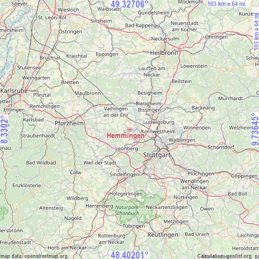
Hemmingen GPS coordinates[2]
48° 52' 0.012" North, 9° 1' 59.988" East
| Map corner | latitude | longitude |
|---|---|---|
| Upper-left | 49.32706°, | 8.3302° |
| Center: | 48.86667°, | 9.03333° |
| Lower-right: | 48.40201°, | 9.73645° |
| Map W x H: | 102.9×102.9 km | = 63.9×63.9mi |
| max Lat: | 55.01917° ⇑84.5% North |
| Hemmingen: | 48.86667° |
| min Lat: | ⇓15.5% South 47.40724° |
| min Long | Hemmingen | max Long |
| 5.92978° | 9.03333° | 14.98853° |
| W 35%⇐ | ⇒65% E |
Elevation
Elevation of Hemmingen is 323 m = 1060 ft, and this is 73.9 m = 242 ft above average elevation for this country.
| Max E: |
1256 m = 4121 ft | 34.8% |
| Hemmingen | 323 m 1060 ft | |
| Avg. | 249.1 m = 817 ft | |
Min E: |
-5 m = -16 ft | 65.2% |
See also: Germany elevation on elevation.city.
Geographical zone
Hemmingen is located in North temperate zone (between Tropic of Cancer and the Arctic Circle). Distance of this North polar circle is 1967.7 km =1222.7 mi to North.| Distance of | km | miles | from Hemmingen |
|---|---|---|---|
| North Pole | 4573.6 | 2841.9 | to North |
| Arctic Circle | 1967.7 | 1222.7 | to North |
| Tropic Cancer | 2827.5 | 1756.9 | to South |
| Equator | 5433.5 | 3376.2 | to South |


Nearby cities:
15 places around Hemmingen: (largest is in red/bold)
• Asperg
8.6 km =5.3 mi,  60°
60°
• Ditzingen
5.1 km =3.2 mi,  150°
150°
• Eberdingen
5.2 km =3.2 mi,  285°
285°
• Gerlingen
7.8 km =4.8 mi,  163°
163°
• Korntal
7.5 km =4.7 mi,  120°
120°
• Leonberg
7.5 km =4.7 mi,  189°
189°
• Markgröningen
5.5 km =3.4 mi,  39°
39°
• Möglingen
7.2 km =4.5 mi,  71°
71°
• Oberriexingen
6.7 km =4.2 mi,  356°
356°
• Rutesheim
9.2 km =5.7 mi,  224°
224°
• Sachsenheim
10.6 km =6.6 mi,  12°
12°
• Schwieberdingen
3.2 km =2 mi, 70°
• Tamm
8.4 km =5.2 mi,  45°
45°
• Vaihingen an der Enz
9.3 km =5.8 mi,  325°
325°
• Weissach
8 km =5 mi,  254°
254°
Sources, notices
• [Note1] Compared only with cities in Germany existing in our database
• [Src1] Map data: © OpenStreetMap contributors (CC-BY-SA)
• [Src2] Other city data from geonames.org with taken over terms of usage.
• [Src3] Geographical zone / Annual Mean Temperature by Robert A. Rohde @ Wikipedia
